Natural and Artificial Reefs at Mar del Plata, Argentina · Natural and Artificial Reefs at Mar del...
14
www.aprh.pt/rgci www.gci.inf.br Revista da Gestão Costeira Integrada 10(1):81-93 (2010) Journal of Integrated Coastal Zone Management 10(1):81-93 (2010) * Submissão – 18 Setembro 2009; Avaliação – 18 Novembro 2009; Recepção da versão revista – 9 Novembro 2009; Disponibilização on-line - 18 Janeiro 2010 Natural and Artificial Reefs at Mar del Plata, Argentina Recifes Naturais e Artificiais em Mar del Plata, Argentina Federico Ignacio Isla 1 1 - CONICET-Universidad Nacional de Mar del Plata, Instituto de Geología de Costas y del Cuaternario, [email protected] ABSTRACT Integrated coastal zone management techniques usually search the preferences of the owners of the coastal properties but without considering the beach users. Multipurpose artificial reefs are submerged structures built in order to diminish wave action, to modify breaker conditions, to protect the coast, and to increase marine biodiversity. Alternatives construction types are considered in relation to the surfing quality of the waves of Mar del Plata. Although detached emerged breakwaters and low-crested submerged structures have been successfully applied to protect beaches from breaking waves, the artificial surfing reefs can improve breaker conditions for recreational purposes. Both structures may increase sand accumulation at the beach if it is naturally available; if not the beaches should be artificially nourished. Based on knowledge of the littoral transport and the bottom composition of the Ensenada Mogotes, artificial submerged reefs, combined with nourishment efforts, are proposed to recover the beach called Los Acantilados. The surfing conditions can improve as a surplus to the stability of the rocky-sandy nearshore ecosystem. Keywords: Artificial Surfing Reefs – Mar del Plata – Ensenada Mogotes - side-scan survey RESUMO As técnicas de gestão integrada da zona costeira são normalmente direccionadas para a protecção dos interesses dos donos das propriedades costeiras e menosprezam, ou não consideram, os interesses dos utentes das praias. Os recifes artificiais multi-funcionais são estruturas submersas construídas para mitigar ou reduzir a acção das ondas, modificar/melhorar as condições de rebentação, proteger a zona costeira (em particular, campos dunares e praias) e aumentar a biodiversidade marinha. São abordadas construções alternativas relativamente à qualidade das ondas para a prática de surf em Mar del Plata. Embora construções clássicas como quebra-mares destacados e estruturas submersas tenham revelado sucesso na protecção da praia, os recifes artificiais multi-funcionais permitem melhorar as ondas para a prática de surf e outros fins recreativos. Ambos os tipos de estruturas promovem alguma acumulação de areia na praia, se esta estiver naturalmente disponível; não existindo, a praia
Transcript of Natural and Artificial Reefs at Mar del Plata, Argentina · Natural and Artificial Reefs at Mar del...
www.aprh.pt/rgciwww.gci.inf.br
Revista da Gestão Costeira Integrada 10(1):81-93 (2010)Journal of Integrated Coastal Zone Management 10(1):81-93 (2010)
* Submissão – 18 Setembro 2009; Avaliação – 18 Novembro 2009; Recepção da versão revista – 9 Novembro 2009; Disponibilização on-line - 18 Janeiro 2010
Natural and Artificial Reefs at Mar del Plata, Argentina
Recifes Naturais e Artificiais em Mar del Plata, Argentina
Federico Ignacio Isla 1
1 - CONICET-Universidad Nacional de Mar del Plata, Instituto de Geología de Costas y del Cuaternario, [email protected]
ABSTRACT
Integrated coastal zone management techniques usually search the preferences of the owners of the coastal propertiesbut without considering the beach users. Multipurpose artificial reefs are submerged structures built in order to diminishwave action, to modify breaker conditions, to protect the coast, and to increase marine biodiversity. Alternatives constructiontypes are considered in relation to the surfing quality of the waves of Mar del Plata. Although detached emerged breakwatersand low-crested submerged structures have been successfully applied to protect beaches from breaking waves, the artificialsurfing reefs can improve breaker conditions for recreational purposes. Both structures may increase sand accumulationat the beach if it is naturally available; if not the beaches should be artificially nourished. Based on knowledge of thelittoral transport and the bottom composition of the Ensenada Mogotes, artificial submerged reefs, combined withnourishment efforts, are proposed to recover the beach called Los Acantilados. The surfing conditions can improve as asurplus to the stability of the rocky-sandy nearshore ecosystem.
Keywords: Artificial Surfing Reefs – Mar del Plata – Ensenada Mogotes - side-scan survey
RESUMO
As técnicas de gestão integrada da zona costeira são normalmente direccionadas para a protecção dos interesses dos donos das propriedadescosteiras e menosprezam, ou não consideram, os interesses dos utentes das praias. Os recifes artificiais multi-funcionais são estruturas submersasconstruídas para mitigar ou reduzir a acção das ondas, modificar/melhorar as condições de rebentação, proteger a zona costeira (em particular,campos dunares e praias) e aumentar a biodiversidade marinha. São abordadas construções alternativas relativamente à qualidade das ondaspara a prática de surf em Mar del Plata. Embora construções clássicas como quebra-mares destacados e estruturas submersas tenham reveladosucesso na protecção da praia, os recifes artificiais multi-funcionais permitem melhorar as ondas para a prática de surf e outros fins recreativos.Ambos os tipos de estruturas promovem alguma acumulação de areia na praia, se esta estiver naturalmente disponível; não existindo, a praia
Federico Ignacio IslaRevista de Gestão Costeira Integrada / Journal of Integrated Coastal Zone Management 10(1):81-93 (2010)
- 82 -
1. INTRODUCTION
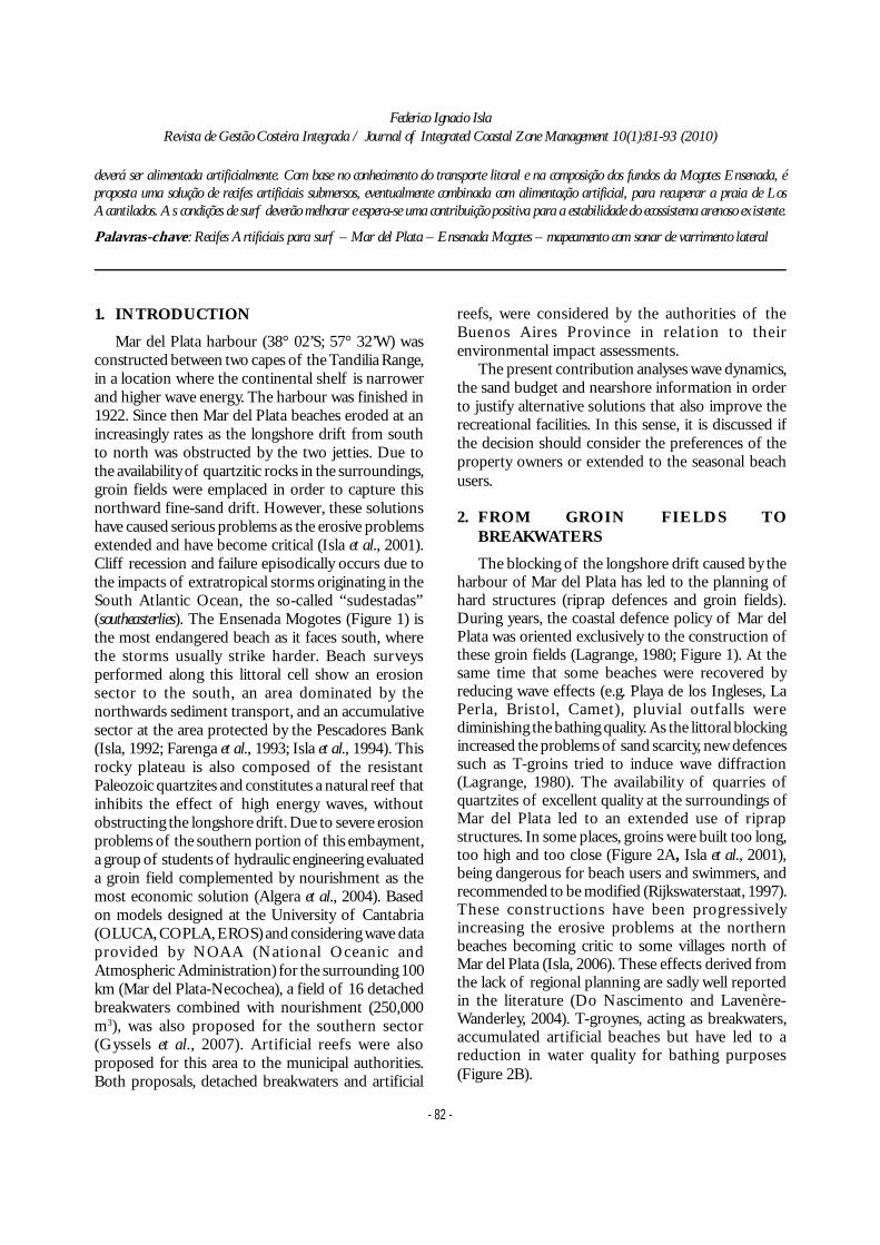
Mar del Plata harbour (38° 02’S; 57° 32’W) wasconstructed between two capes of the Tandilia Range,in a location where the continental shelf is narrowerand higher wave energy. The harbour was finished in1922. Since then Mar del Plata beaches eroded at anincreasingly rates as the longshore drift from southto north was obstructed by the two jetties. Due tothe availability of quartzitic rocks in the surroundings,groin fields were emplaced in order to capture thisnorthward fine-sand drift. However, these solutionshave caused serious problems as the erosive problemsextended and have become critical (Isla et al., 2001).Cliff recession and failure episodically occurs due tothe impacts of extratropical storms originating in theSouth Atlantic Ocean, the so-called “sudestadas”(southeasterlies). The Ensenada Mogotes (Figure 1) isthe most endangered beach as it faces south, wherethe storms usually strike harder. Beach surveysperformed along this littoral cell show an erosionsector to the south, an area dominated by thenorthwards sediment transport, and an accumulativesector at the area protected by the Pescadores Bank(Isla, 1992; Farenga et al., 1993; Isla et al., 1994). Thisrocky plateau is also composed of the resistantPaleozoic quartzites and constitutes a natural reef thatinhibits the effect of high energy waves, withoutobstructing the longshore drift. Due to severe erosionproblems of the southern portion of this embayment,a group of students of hydraulic engineering evaluateda groin field complemented by nourishment as themost economic solution (Algera et al., 2004). Basedon models designed at the University of Cantabria(OLUCA, COPLA, EROS) and considering wave dataprovided by NOAA (National Oceanic andAtmospheric Administration) for the surrounding 100km (Mar del Plata-Necochea), a field of 16 detachedbreakwaters combined with nourishment (250,000m3), was also proposed for the southern sector(Gyssels et al., 2007). Artificial reefs were alsoproposed for this area to the municipal authorities.Both proposals, detached breakwaters and artificial
reefs, were considered by the authorities of theBuenos Aires Province in relation to theirenvironmental impact assessments.
The present contribution analyses wave dynamics,the sand budget and nearshore information in orderto justify alternative solutions that also improve therecreational facilities. In this sense, it is discussed ifthe decision should consider the preferences of theproperty owners or extended to the seasonal beachusers.
2. FROM GROIN FIELDS TOBREAKWATERS
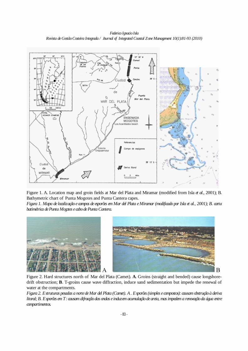
The blocking of the longshore drift caused by theharbour of Mar del Plata has led to the planning ofhard structures (riprap defences and groin fields).During years, the coastal defence policy of Mar delPlata was oriented exclusively to the construction ofthese groin fields (Lagrange, 1980; Figure 1). At thesame time that some beaches were recovered byreducing wave effects (e.g. Playa de los Ingleses, LaPerla, Bristol, Camet), pluvial outfalls werediminishing the bathing quality. As the littoral blockingincreased the problems of sand scarcity, new defencessuch as T-groins tried to induce wave diffraction(Lagrange, 1980). The availability of quarries ofquartzites of excellent quality at the surroundings ofMar del Plata led to an extended use of riprapstructures. In some places, groins were built too long,too high and too close (Figure 2A, Isla et al., 2001),being dangerous for beach users and swimmers, andrecommended to be modified (Rijkswaterstaat, 1997).These constructions have been progressivelyincreasing the erosive problems at the northernbeaches becoming critic to some villages north ofMar del Plata (Isla, 2006). These effects derived fromthe lack of regional planning are sadly well reportedin the literature (Do Nascimento and Lavenère-Wanderley, 2004). T-groynes, acting as breakwaters,accumulated artificial beaches but have led to areduction in water quality for bathing purposes(Figure 2B).
deverá ser alimentada artificialmente. Com base no conhecimento do transporte litoral e na composição dos fundos da Mogotes Ensenada, éproposta uma solução de recifes artificiais submersos, eventualmente combinada com alimentação artificial, para recuperar a praia de LosAcantilados. As condições de surf deverão melhorar e espera-se uma contribuição positiva para a estabilidade do ecossistema arenoso existente.
Palavras-chave: Recifes Artificiais para surf – Mar del Plata – Ensenada Mogotes – mapeamento com sonar de varrimento lateral
Federico Ignacio IslaRevista de Gestão Costeira Integrada / Journal of Integrated Coastal Zone Management 10(1):81-93 (2010)
- 83 -
Figure 1. A. Location map and groin fields at Mar del Plata and Miramar (modified from Isla et al., 2001); B.Bathymetric chart of Punta Mogotes and Punta Cantera capes.Figura 1. Mapa de localização e campos de esporões em Mar del Plata e Miramar (modificado por Isla et al., 2001); B. cartabatimétrica de Punta Mogotes e cabo de Punta Cantera.
Figure 2. Hard structures north of Mar del Plata (Camet). A. Groins (straight and bended) cause longshore-drift obstruction; B. T-groins cause wave diffraction, induce sand sedimentation but impede the renewal ofwater at the compartments.Figura 2. Estruturas pesadas a norte de Mar del Plata (Camet). A. Esporões (simples e compostos): causam obstrução à derivalitoral; B. Esporões em T: causam difracção das ondas e induzem acumulação de areia, mas impedem a renovação da água entrecompartimentos.
Federico Ignacio IslaRevista de Gestão Costeira Integrada / Journal of Integrated Coastal Zone Management 10(1):81-93 (2010)
- 84 -
3. FROM BREAKWATERS TO ARTIFICIALREEFS AND LOW-CRESTEDSTRUCTURES
Reef breakwaters were usually recommended toreduce sediment transport at harbour entrances(Carver and Bottin, 1997). One of the firsts offshorebreakwaters was constructed in1968 to assure theaccess of the Ventura Harbour (California); later itwas subject to several changes (Hughes andSchwichtemberg, 1998). At the beginning of thenineties, the Coastal Engineering Research Center(CERC) considered nearshore berms to attenuatewave energy for coastal protection (Pollock et al., 1993;Allison and Pollock, 1993; Williams et al., 1993). In1997 rapidly installed breakwaters (RIB) wereproposed to protect the Outer Banks of NorthCarolina (Fowler et al., 1997). To predict tombolosor salient formation several practical rules are applied,supplemented by physical model tests (Zyserman andJohnson, 2002). However, several attempts failed as aregional coastal-defence solution (Edwards, 2006).
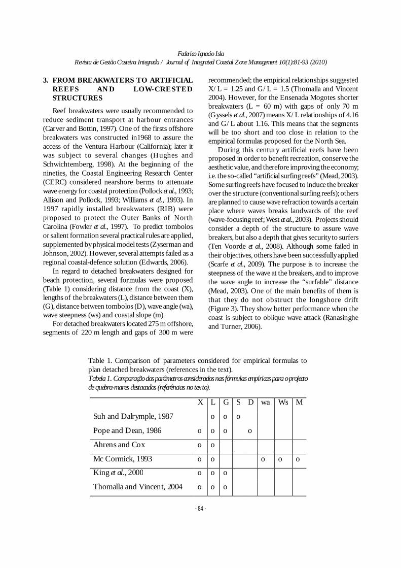
In regard to detached breakwaters designed forbeach protection, several formulas were proposed(Table 1) considering distance from the coast (X),lengths of the breakwaters (L), distance between them(G), distance between tombolos (D), wave angle (wa),wave steepness (ws) and coastal slope (m).
For detached breakwaters located 275 m offshore,segments of 220 m length and gaps of 300 m were
recommended; the empirical relationships suggestedX/L = 1.25 and G/L = 1.5 (Thomalla and Vincent2004). However, for the Ensenada Mogotes shorterbreakwaters (L = 60 m) with gaps of only 70 m(Gyssels et al., 2007) means X/L relationships of 4.16and G/L about 1.16. This means that the segmentswill be too short and too close in relation to theempirical formulas proposed for the North Sea.
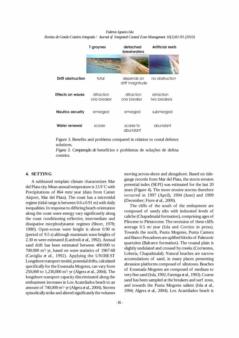
During this century artificial reefs have beenproposed in order to benefit recreation, conserve theaesthetic value, and therefore improving the economy;i.e. the so-called “artificial surfing reefs” (Mead, 2003).Some surfing reefs have focused to induce the breakerover the structure (conventional surfing reefs); othersare planned to cause wave refraction towards a certainplace where waves breaks landwards of the reef(wave-focusing reef; West et al., 2003). Projects shouldconsider a depth of the structure to assure wavebreakers, but also a depth that gives security to surfers(Ten Voorde et al., 2008). Although some failed intheir objectives, others have been successfully applied(Scarfe et al., 2009). The purpose is to increase thesteepness of the wave at the breakers, and to improvethe wave angle to increase the “surfable” distance(Mead, 2003). One of the main benefits of them isthat they do not obstruct the longshore drift(Figure 3). They show better performance when thecoast is subject to oblique wave attack (Ranasingheand Turner, 2006).
Table 1. Comparison of parameters considered for empirical formulas toplan detached breakwaters (references in the text).Tabela 1. Comparação dos parâmetros considerados nas fórmulas empíricas para o projectode quebra-mares destacados (referências no texto).
X L G S D wa Ws M
Suh and Dalrymple, 1987 o o o
Pope and Dean, 1986 o o o o
Ahrens and Cox o o
Mc Cormick, 1993 o o o o o
King et al., 2000 o o o
Thomalla and Vincent, 2004 o o o
Federico Ignacio IslaRevista de Gestão Costeira Integrada / Journal of Integrated Coastal Zone Management 10(1):81-93 (2010)
- 85 -
4. SETTING
A subhumid template climate characterizes Mardel Plata city. Mean annual temperature is 13.9 ºC withPrecipitations of 864 mm/year (data from CametAirport, Mar del Plata). The coast has a microtidalregime (tidal range is between 0.6 a 0.91 m) with dailyinequalities. In response to differing beach orientationalong the coast wave energy vary significantly alongthe coast conditioning reflective, intermediate anddissipative morphodynamic regimes (Short, 1978;1980). Open-ocean wave height is about 0.90 m(period of 9.5 s) although maximum wave heights of2.30 m were estimated (Lanfredi et al., 1992). Annualsand drift has been estimated between 400.000 to700.000 m3/yr, based on wave statistics of 1967-68(Caviglia et al., 1992). Applying the UNIBESTLongshore transport model, potential drifts, calculatedspecifically for the Ensenada Mogotes, can vary from250,000 to 1,230,000 m3/yr (Algera et al., 2004). Thelongshore transport capacity discriminated along theembayment increases in Los Acantilados beach to anamount of 740,000 m3/yr (Algera et al., 2004). Stormsepisodically strike and altered significantly the volumes
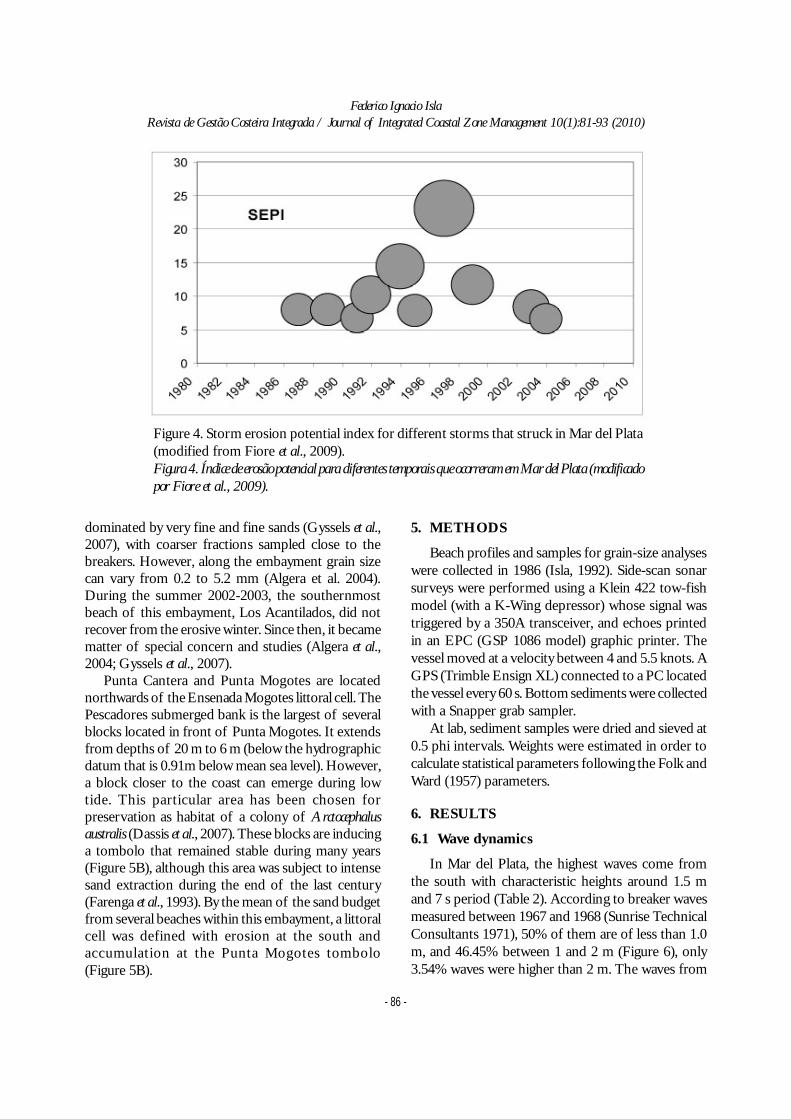
moving across-shore and alongshore. Based on tide-gauge records from Mar del Plata, the storm erosionpotential index (SEPI) was estimated for the last 20years (Figure 4). The more erosive storms thereforeoccurred in 1997 (April), 1994 (June) and 1999(December; Fiore et al., 2009).
The cliffs of the south of the embayment arecomposed of sandy silts with indurated levels ofcaliche (Chapadmalal formation), comprising ages ofPliocene to Pleistocene. The recession of these cliffsaverage 0.5 m/year (Isla and Cortizo in press).Towards the north, Punta Mogotes, Punta Canteraand Banco Pescadores are uplifted blocks of Paleozoicquartzites (Balcarce formation). The coastal plain isslightly undulated and crossed by creeks (Corrientes,Lobería, Chapadmalal). Natural beaches are narrowaccumulations of sand, in many places presentingabrassion platforms composed of siltstones. Beachesof Ensenada Mogotes are composed of medium tovery fine sand (Isla, 1992; Farenga et al., 1993). Coarsesand has been sampled at the breakers and surf zone,and towards the Punta Mogotes salient (Isla et al.,1994; Algera et al., 2004). Los Acantilados beach is
Figure 3. Benefits and problems compared in relation to costal defencesolutions.Figura 3. Comparação de benefícios e problemas de soluções de defesacosteira.
Federico Ignacio IslaRevista de Gestão Costeira Integrada / Journal of Integrated Coastal Zone Management 10(1):81-93 (2010)
- 86 -
dominated by very fine and fine sands (Gyssels et al.,2007), with coarser fractions sampled close to thebreakers. However, along the embayment grain sizecan vary from 0.2 to 5.2 mm (Algera et al. 2004).During the summer 2002-2003, the southernmostbeach of this embayment, Los Acantilados, did notrecover from the erosive winter. Since then, it becamematter of special concern and studies (Algera et al.,2004; Gyssels et al., 2007).
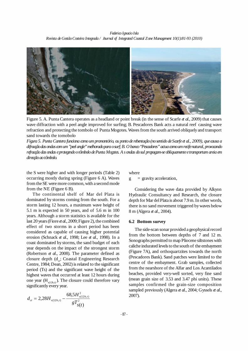
Punta Cantera and Punta Mogotes are locatednorthwards of the Ensenada Mogotes littoral cell. ThePescadores submerged bank is the largest of severalblocks located in front of Punta Mogotes. It extendsfrom depths of 20 m to 6 m (below the hydrographicdatum that is 0.91m below mean sea level). However,a block closer to the coast can emerge during lowtide. This particular area has been chosen forpreservation as habitat of a colony of Arctocephalusaustralis (Dassis et al., 2007). These blocks are inducinga tombolo that remained stable during many years(Figure 5B), although this area was subject to intensesand extraction during the end of the last century(Farenga et al., 1993). By the mean of the sand budgetfrom several beaches within this embayment, a littoralcell was defined with erosion at the south andaccumulation at the Punta Mogotes tombolo(Figure 5B).
5. METHODS
Beach profiles and samples for grain-size analyseswere collected in 1986 (Isla, 1992). Side-scan sonarsurveys were performed using a Klein 422 tow-fishmodel (with a K-Wing depressor) whose signal wastriggered by a 350A transceiver, and echoes printedin an EPC (GSP 1086 model) graphic printer. Thevessel moved at a velocity between 4 and 5.5 knots. AGPS (Trimble Ensign XL) connected to a PC locatedthe vessel every 60 s. Bottom sediments were collectedwith a Snapper grab sampler.
At lab, sediment samples were dried and sieved at0.5 phi intervals. Weights were estimated in order tocalculate statistical parameters following the Folk andWard (1957) parameters.
6. RESULTS
6.1 Wave dynamics
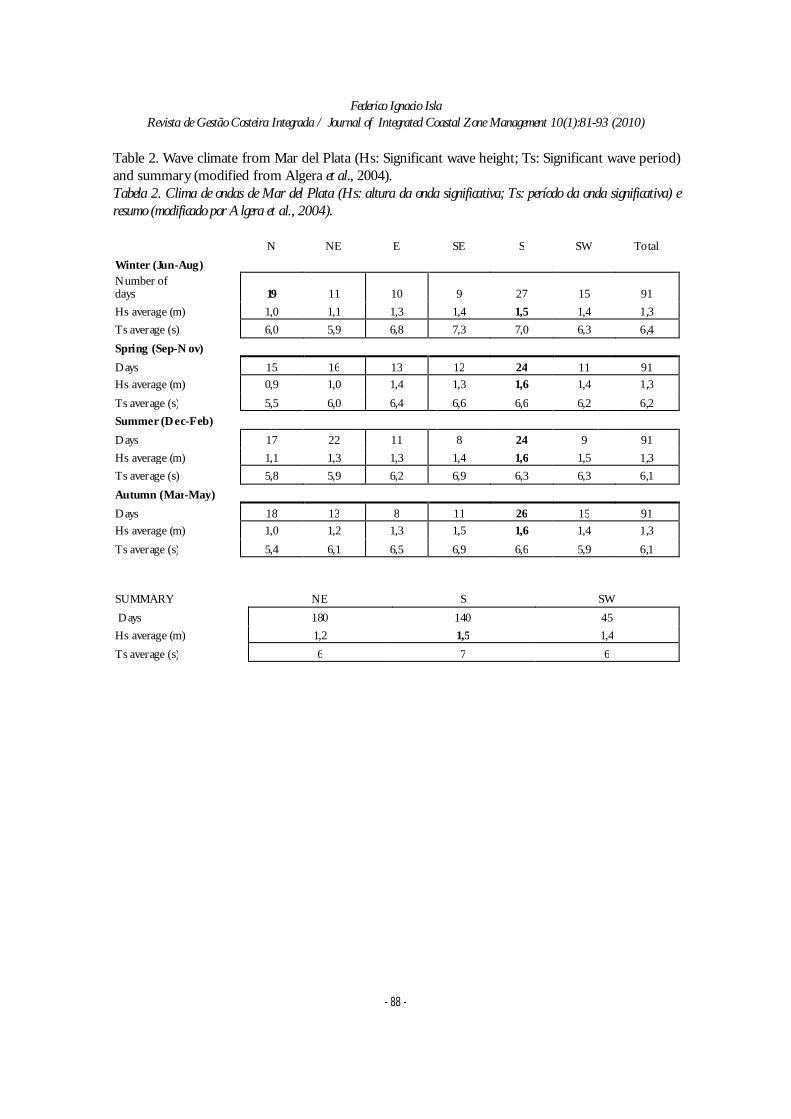
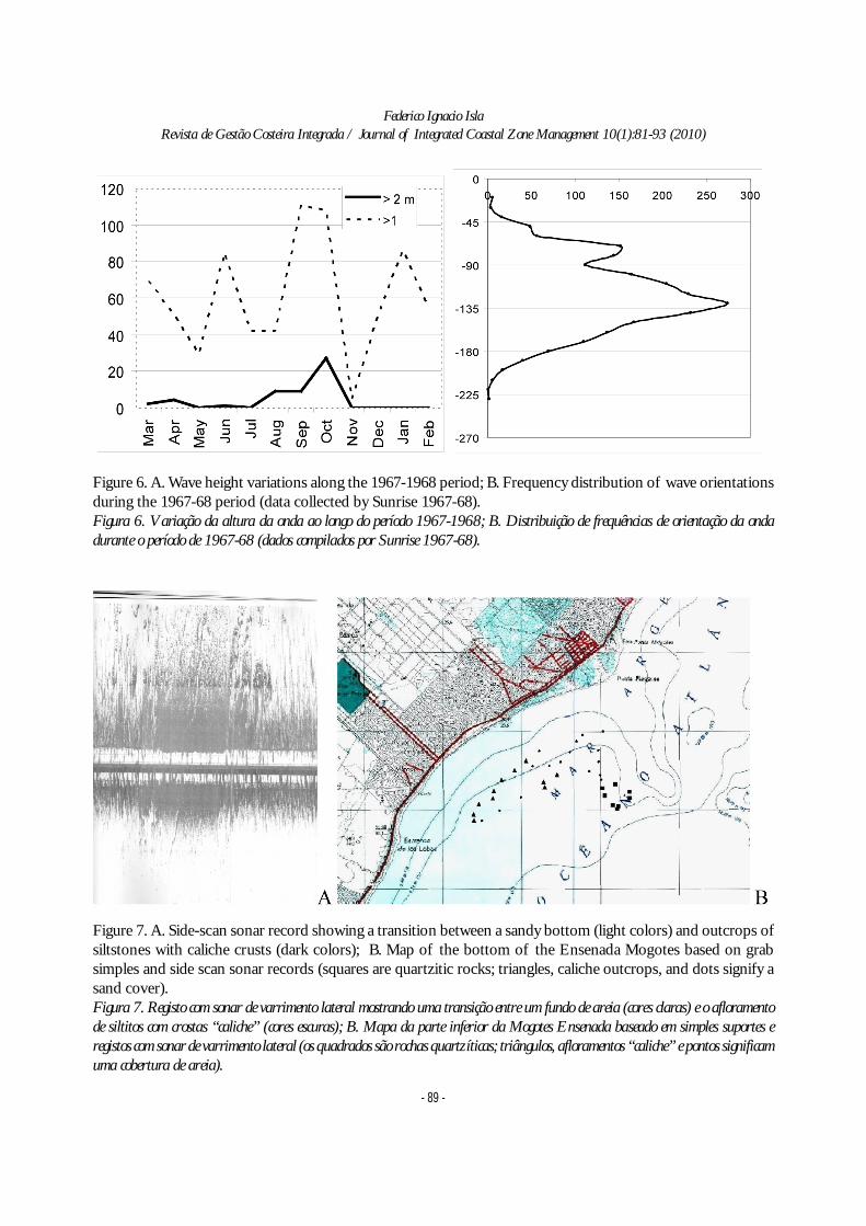
In Mar del Plata, the highest waves come fromthe south with characteristic heights around 1.5 mand 7 s period (Table 2). According to breaker wavesmeasured between 1967 and 1968 (Sunrise TechnicalConsultants 1971), 50% of them are of less than 1.0m, and 46.45% between 1 and 2 m (Figure 6), only3.54% waves were higher than 2 m. The waves from
Figure 4. Storm erosion potential index for different storms that struck in Mar del Plata(modified from Fiore et al., 2009).Figura 4. Índice de erosão potencial para diferentes temporais que ocorreram em Mar del Plata (modificadopor Fiore et al., 2009).
Federico Ignacio IslaRevista de Gestão Costeira Integrada / Journal of Integrated Coastal Zone Management 10(1):81-93 (2010)
- 87 -
the S were higher and with longer periods (Table 2)occurring mostly during spring (Figure 6 A). Wavesfrom the SE were more common, with a second modefrom the NE (Figure 6 B).
The continental shelf of Mar del Plata isdominated by storms coming from the south. For astorm lasting 12 hours, a maximum wave height of5.1 m is expected in 50 years, and of 5.6 m in 100years. Although a storm statistics is available for thelast 20 years (Fiore et al., 2009; Figure 2), the combinedeffect of two storms in a short period has beenconsidered as capable of causing higher potentialerosion (Schnack et al., 1998; Lee et al., 1998). In acoast dominated by storms, the sand budget of eachyear depends on the impact of the strongest storm(Robertson et al., 2008). The parameter defined asclosure depth (d
ct; Coastal Engineering Research
Centre, 1984; Dean, 2002) is related to the significantperiod (Ts) and the significant wave height of thehighest waves that occurred at least 12 hours duringone year (H
s(12h,t) ). The closure could therefore vary
significantly every year.
2
2),12(
),12(
)(
5,6828,2
tsgT
HHd ths
thsct
whereg = gravity acceleration,
Considering the wave data provided by AlkyonHydraulic Consultancy and Research, the closuredepth for Mar del Plata is about 7.9 m. In other words,there is no sand movement triggered by waves below8 m (Algera et al., 2004).
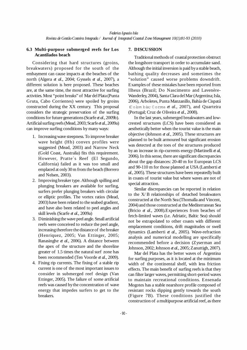
6.2 Bottom survey
The side-scan sonar provided a geophysical recordfrom the bottom between depths of 7 and 12 m.Sonographs permitted to map Pliocene siltstones withcaliche indurated levels to the south of the embayment(Figure 7A), and orthoquartzites towards the north(Pescadores Bank). Sand patches were limited to thecentre of the embayment. Grab samples, collectedfrom the nearshore of the Alfar and Los Acantiladosbeaches, provided very-well sorted, very fine sand(mean grain size of 3.53 and 3.47 phi units). Thesesamples confirmed the grain-size compositionsampled previously (Algera et al., 2004; Gyssels et al.,2007).
Figure 5. A. Punta Cantera operates as a headland or point break (in the sense of Scarfe et al., 2009) that causeswave diffraction with a peel angle improved for surfing; B. Pescadores Bank acts a natural reef causing waverefraction and protecting the tombolo of Punta Mogotes. Waves from the south arrived obliquely and transportsand towards the tomoboloFigura 5. Punta Cantera funciona como um promontório, ou ponto de rebentação (no sentido de Scarfe et al., 2009), que causa adifracção das ondas com um ”peel angle” melhorado para o surf; B. O banco “Pescadores” actua como um recife natural, provocandorefracção das ondas e protegendo o tômbolo de Punta Mogotes. As ondas do sul propagam-se obliquamente e transportam areia emdirecção ao tômbolo.
Federico Ignacio IslaRevista de Gestão Costeira Integrada / Journal of Integrated Coastal Zone Management 10(1):81-93 (2010)
- 88 -
N NE E SE S SW Total
Winter (Jun-Aug)Number of days 19 11 10 9 27 15 91
Hs average (m) 1,0 1,1 1,3 1,4 1,5 1,4 1,3
Ts average (s) 6,0 5,9 6,8 7,3 7,0 6,3 6,4
Spring (Sep-Nov)
Days 15 16 13 12 24 11 91
Hs average (m) 0,9 1,0 1,4 1,3 1,6 1,4 1,3
Ts average (s) 5,5 6,0 6,4 6,6 6,6 6,2 6,2
Summer (Dec-Feb)
Days 17 22 11 8 24 9 91
Hs average (m) 1,1 1,3 1,3 1,4 1,6 1,5 1,3
Ts average (s) 5,8 5,9 6,2 6,9 6,3 6,3 6,1
Autumn (Mar-May)
Days 18 13 8 11 26 15 91
Hs average (m) 1,0 1,2 1,3 1,5 1,6 1,4 1,3
Ts average (s) 5,4 6,1 6,5 6,9 6,6 5,9 6,1
Table 2. Wave climate from Mar del Plata (Hs: Significant wave height; Ts: Significant wave period)and summary (modified from Algera et al., 2004).Tabela 2. Clima de ondas de Mar del Plata (Hs: altura da onda significativa; Ts: período da onda significativa) eresumo (modificado por Algera et al., 2004).
SUMMARY NE S SW
Days 180 140 45
Hs average (m) 1,2 1,5 1,4
Ts average (s) 6 7 6
Federico Ignacio IslaRevista de Gestão Costeira Integrada / Journal of Integrated Coastal Zone Management 10(1):81-93 (2010)
- 89 -
Figure 6. A. Wave height variations along the 1967-1968 period; B. Frequency distribution of wave orientationsduring the 1967-68 period (data collected by Sunrise 1967-68).Figura 6. Variação da altura da onda ao longo do período 1967-1968; B. Distribuição de frequências de orientação da ondadurante o período de 1967-68 (dados compilados por Sunrise 1967-68).
Figure 7. A. Side-scan sonar record showing a transition between a sandy bottom (light colors) and outcrops ofsiltstones with caliche crusts (dark colors); B. Map of the bottom of the Ensenada Mogotes based on grabsimples and side scan sonar records (squares are quartzitic rocks; triangles, caliche outcrops, and dots signify asand cover).Figura 7. Registo com sonar de varrimento lateral mostrando uma transição entre um fundo de areia (cores claras) e o afloramentode siltitos com crostas “caliche” (cores escuras); B. Mapa da parte inferior da Mogotes Ensenada baseado em simples suportes eregistos com sonar de varrimento lateral (os quadrados são rochas quartzíticas; triângulos, afloramentos “caliche” e pontos significamuma cobertura de areia).
Federico Ignacio IslaRevista de Gestão Costeira Integrada / Journal of Integrated Coastal Zone Management 10(1):81-93 (2010)
- 90 -
6.3 Multi-purpose submerged reefs for LosAcantilados beach
Considering that hard structures (groins,breakwaters) proposed for the south of theembayment can cause impacts at the beaches of thenorth (Algera et al., 2004; Gyssels et al., 2007), adifferent solution is here proposed. These beachesare, at the same time, the most attractive for surfingactivities. Most “point breaks” of Mar del Plata (PuntaGruta, Cabo Corrientes) were spoiled by groinsconstructed during the XX century. This proposalconsiders the strategic preservation of the surfingconditions for future generations (Scarfe et al., 2009b).Artificial surfing reefs (Mead, 2003; Scarfe et al., 2009a)can improve surfing conditions by many ways:
1. Increasing wave steepness. To improve breakerwave height (Hb) convex profiles weresuggested (Mead, 2003) and Narrow Neck(Gold Coast, Australia) fits this requirement.However, Pratte´s Reef (El Segundo,California) failed as it was too small andemplaced at only 30 m from the beach (Borreroand Nelsen, 2003).
2. Improving breaker type. Although spilling andplunging breakers are available for surfing,surfers prefer plunging breakers with circularor elliptic profiles. The vortex ratios (Mead,2003) have been related to the seabed gradient,and have also been related to peel angles andskill levels (Scarfe et al., 2009a)
3. Diminishing the wave peel angle. Small artificialreefs were conceived to reduce the peel angle,increasing therefore the distance of the breaker(Henriquez, 2005; Van Ettinger, 2005;Ranasinghe et al., 2006). A distance betweenthe apex of the structure and the shorelinegreater of 1.5 times the natural surf zone hasbeen recommended (Ten Voorde et al., 2009).
4. Fixing rip currents. The fixing of a stable ripcurrent is one of the most important issues toconsider in submerged reef design (VanEttinger, 2005). The failure of some artificialreefs was caused by the concentration of waveenergy that impedes surfers to get to thebreakers.
7. DISCUSSION
Traditional methods of coastal protection obstructthe longshore transport in order to accumulate sand.Although the initial inversion is paid by a stable beach,bathing quality decreases and sometimes the“solution” caused worse problems downdrift.Examples of these mistakes have been reported fromIlheus (Brazil; Do Nascimento and Lavenère-Wanderley, 2004), Santa Clara del Mar (Argentina; Isla,2006), Arboletes, Punta Manzanillo, Bahía de Cispatá(Colom bia; Correa et al., 2007), and Quarteira(Portugal; Cruz de Oliveira et al., 2008).
In the last years, submerged breakwaters and low-crested structures (LCS) have been considered asaesthetically better when the tourist value is the mainobjective (Johnson et al., 2005). These structures areplanned to be built armoured but significant erosionwas detected at the toes of the structures producedby an increase in rip-currents energy (Martinelli et al,2006). In this sense, there are significant discrepanciesabout the gap distances: 20-40 m for European LCSand 90-110 m for those planned at USA (Lamberti etal., 2005). These structures have been repeatedly builtin coasts of tourist value but where waves are not ofspecial attraction.
Similar discrepancies can be reported in relationto the X/B relationships of detached breakwatersconstructed at the North Sea (Thomalla and Vincent,2004) and those constructed at the Mediterranean Sea(Bricio et al., 2008).Experiences from beaches offetch-limited waves (i.e. Adriatic, Baltic Sea) shouldnot be extrapolated to other coasts with differentemplacement conditions, drift magnitudes or swelldynamics (Lamberti et al., 2005). Wave-refractionanalysis and numerical modelling are specificallyrecommended before a decision (Zyserman andJohnson, 2002; Johnson et al., 2005; Zanuttigh, 2007).
Mar del Plata has the better waves of Argentinafor surfing purposes, as it is located at the minimumwidth of the continental shelf, with less frictioneffects. The main benefit of surfing reefs is that theycan filter larger waves, permitting short-period wavesto maintain recreational conditions. EnsenadaMogotes has a stable nearshore profile composed ofresistant rocks dipping gently towards the south(Figure 7B). These conditions justified theconstruction of a multipurpose artificial reef, as there
Federico Ignacio IslaRevista de Gestão Costeira Integrada / Journal of Integrated Coastal Zone Management 10(1):81-93 (2010)
- 91 -
is no risk of sinking of the structure. Large reefs aresubject to erosion at their bases and therefore can beslowly sinking on nearhsore zones dominated by sand.Geotextile sand bags were preferentially chosen forreef construction as they are more easily removed, ifnecessary.
In regard to controversies related to theeconomically affordable solution, it is alsorecommended to consult neighbours and beach users.As the economic benefit of surfing breaks to coastalcommunities can be disregarded in Integrated CoastalZone Management programs, this issue should beincluded in Evaluation of Impact Assessmentsprotocols (Scarfe et al., 2009b). Surfing conditions arevery fragile and should be considered as another issueto preserve for future generations.
8. CONCLUSIONS
1. The natural reef of Punta Mogotes has provenits efficiency filtering larger waves and inducingsediment accumulation and beach stability.
2. Groins and detached breakwaters can cause theobstruction of longshore drift at EnsenadaMogotes and therefore could increase erosionproblems.
3. Artificial reefs, combined with beach nourishment,are recommended as they induced less impact andare easily removed, if necessary.
4. Surfing conditions and breakers preservationshould be also considered in EIA protocols.
ACKNOWLEDGEMENTS
The author wishes to thank those who helpedduring the samplings and surveys. The survey withside-scan sonar was performed on the coastguardvessel Río Luján (Prefectura Naval Mar del Plata).Gustavo Huici, Surfrider Foundation Argentina,encouraged this study at several stages. A. Algera, B.Burger, W. Hartog y Q. De Rijke (TechnischeUniversiteit of Delft, The Netherlands) provideduseful information during their stay in Mar del Plata(2004). Ramón González improved the manuscript.
REFERENCES
Ahrens, J. P. and Cox, J., 1990. Design andperformance of reef breakwaters. Journal ofCoastal Research SI, 7:61-75.
Allison, M. C. and Pollock, Ch. B., 1993. Nearshoreberms: an evaluation of prototype designs. InMagoon, O. T, Wilson, W. S., Converse, H. andTobin, L. T. (eds.) Coastal Zone ’93, Proc. 8th.Symposium on Costal and Ocean Management,ASCE, 2938-2950.
Borrero, J. C. and nelsen, Ch., 2003. Results of acomprehenseive monitoring program at Pratte’sReef. In Black, K.P. and Mead, S. T. (eds.) Artificialsurfing reefs 2003: The 3rd. InternationalConference, Raglan, New Zealand, CDpublication, 83-98.
Bricio, L., Negro, V. and Diez, J. J., 2008. Geometricdetached breakwater indicators on the SpanishNortheast coastline. Journal of Coastal research24, 5, 1289-1303.
Carver, R. D. and Bottin, R. R., 1997, Reef breakwaterdesign for Burns Waterway Harbor, Indiana, U.S.A.Journal of Coastal Research 13(4):1267-1281.
Caviglia, F. J., Pousa, J. L. y Lanfredi, N. W., 1992.Transporte de sedimentos: una alternativa decálculo. II Congreso de Ciencias de la Tierra,Memorias, Santiago, Chile, 413-422.
Coastal Engineering Research Center, 1984. Shoreprotection manual. Department of the Army, Vol.1, Vicksburg, Miss.
Correa, I. D., Acosta, S. and Bedoya, G., 2007. Análisisde las causas y monitoreo de la erosión litoral enel Departamento de Córdoba. Universidad Eafit,Departamento Geología, Medellín, 128 pp.
Cruz de Oliveira, S., Catalâo, J., Ferreira, O. AndAlveirinho Dias, J. M., 2008. Evaluation of cliffretreat and beach nourishment in SouthernPortugal using photogrammetric techniques.Journal of Coastal Research 24, 4C, 184-193.
Dassis, M., 2005.utilización del habitat costero de Mardel Plata por lobos marinos de dos pelos: Suanálisis a partir de Sistemas de InformaciónGeográfica. Unpublished thesis, UniversidadNacional de mar del Plata, Mar del Plata, 74 pp.
Dean, R. G., 2002. Beach nourishment: theory andpractice. World Scientific, Singapore, 399 pp.
Do Nascimento, L. and Lavenère-Wanderley, A. A.,2004. Effect of Shore Protection Structures(Groins) on São Miguel Beach, Ilhéus, Bahia Brazil.Journal of Coastal Research SI 39, 858-862.
Edwards, B. L., 2006.Invesigation of the effects of
Federico Ignacio IslaRevista de Gestão Costeira Integrada / Journal of Integrated Coastal Zone Management 10(1):81-93 (2010)
- 92 -
detached breakwaters at Holly Beach and GrandeIsle, Louisiana. Unpublished thesis, LouisianaState University, 117 pp.
Farenga, M. O., Adamini, R. and Isla, F. I., 1993.Evaluación de playas de intensa extracción dearena: Ensenada Mogotes, Mar del Plata,Argentina, 1987-1990. Revista Thalassas, Univ. deSantiago de Compostela - Univ. de Vigo, 10, 41-47.
Fiore, M., .D’Onofrio, E. E., Pousa, J. L., Schnack, E.J. and Bértola, G. R., 2009. Storm surge and coastalimpacts at Mar del Plata, Argentina. ContinentalShelf Research.29, 1643-1649.
Folk, R. and Ward, W., 1957. Brazos River bar: a studyin the significance of grain size parameters. Journalof Sedimentary Petrology 27 (1): 3-26.
Fowler, J. E., Pollock, Ch. E., Resio, D. T. and Turk,G. F., 1997. Development of a rapidly installedbreakwater (RIB) system. The CERCular. CERC-97-3, 1-4.
Gyssels, P., Ragessi, M., Rodriguez, A., Cardini, J., andCampos, M., 2007. Aplicaciones de modelosnuméricos a un estudio de prediseño de un sistemade diques exentos en el litoral argentino. Mecánicacomputacional XXVI, 1252-1271
Henriquez, M., 2005. Artificial surf reefs.Unpublished Rept., Delft University ofTechnology, Delft, 63 pp.
Hughes, S. A. and Schwichtemberg, B.R., 1998.Current-induced scour along a breakwater atVentura Harbour, CA. Experimental study. CoastalEngineering 34, 1-2, 1-22.
Isla, F. I. 1992. Balance sedimentario y estacionalidaden 8 playas de Mar del Plata. Revista Thalassas,Univ. Santiago de Compostela y Univ. de Vigo,11: 11-21.
Isla, F. I., 2006. Erosión y defensa costeras. En Isla,F. I and Lasta, C. A. (eds.) Manual de Manejocostero para la Provincia de Buenos Aires,EUDEM, Mar del Plata, 125-147.
Isla, F. I., Bértola, G. R., Farenga, M. O. and Cortizo,L. C., 2001. Variaciones antropogénicas de lasplayas del sudeste de Buenos Aires, Argentina.Revista Pesquisas en Geociéncias, UniversidadeFederal do Rio Grande de Sul, 28, 1, 27-35.
Isla, F. I. and Cortizo, L. C, in press. Cliff erosion assediment input to Argentine continental shelf.Geologica Acta, 19 pp.
Isla, F. I., Witkin, G., Bértola, G. R. and Farenga, M.O. 1994. Variaciones morfológicas decenales(1983-1993) de las playas de Mar del Plata. Revistade la Asociación Geológica Argentina 49 (3-4):55-70.
Johnson, H.K., Karambas, T. V., Avgeris, I., Zanuttigh,B, González-Marco, D., Cáceres, I., 2005.Modelling of waves and currents aroundsubmerged breakwaters. Coastal Engineering52:949– 969.
King, D. M., Cooper, N. J, Morfett, J. C, and Pope, D.J., 2000. Application of offshore breakwaters tothe UK: a case study at Elmer Beach. Journal ofCoastal Research 16, 1, 172-187.
Lagrange, A. A., 1993. Mar, playas y puerto. FundaciónBolsa de Comercio de Mar del Plata, Mar del Plata,556 pp.
Lamberti, A., Archetti, R., Kramer, M., Paphitis, D.,Mosso, C. and Di Risio, M., 2005. Europeanexperience of low crested structures for coastalmanagement. Coastal Engineering 52:841–866.
Lanfredi, N. W., Pousa, J. L., Mazio, C. A. and Dragani,W. C. 1992. Wave-power potential along the coastof the Province of Buenos Aires, Argentina.Energy 17(11): 997-1006.
Lee, G., Nicholls, R. J. and Birkemeier, W. A., 1998.Storm-driven variability of the beach-nearshoreprofile at Duck, North Carolina, USA, 1981-1991.Marine Geology 148, 163-177.
Martinelli, L., Zanuttigh, B. and Lamberti, A., 2006.Hydrodynamic and morphodynamic response ofisolated and multiple low crested structures:Experiments and simulations. Coastal Engineering53, 363 – 379.
Mc Cormick, M. E., 1993. Equilibrium shorelineresponse to breakwaters. Journal of Waterways,Ports, Coastal and Ocean Engineering 119(6):657-670.
Mead, S. T, 2003. Surfing science. Proc. 3rd.International. Surfing Reef Conf., Karioi Centre,Raglan, NZ.
Pollock, Ch. E., Allison, M. C. and Williams, G. L.,1993. Designing nearshore berms to optimizewave attenuation. Dredging Research DRP 93-3,4-8.
Pope, J. and Dean, J. L., 1987. Development of designcriteria for segmented breakwaters. Porc. 20th.
Federico Ignacio IslaRevista de Gestão Costeira Integrada / Journal of Integrated Coastal Zone Management 10(1):81-93 (2010)
- 93 -
Intnal. Conference on Coastal Engineering, ASCE,Taiwan, 2144-2158.
Ranasinghe, R. and Turner, I. L., 2006. Shorelineresponse to submerged structures: A review.Coastal Engineering 53, 65-79.
Ranasinghe, R., Turner, I. L. and Symonds, G., 2006.Shoreline response to multi-functional artificialsurfing reefs: a numerical and physical modellingstudy. Coastal Engineering 53:589-611.
Rijkswaterstaat, 1997. Port and coastal study Mar delPlata. Final report. Document WB1062-4-96045,127 pp.
Robertson, W., Zhang, K. Finkl. Ch. W. and Whitman,D., 2008. Hydrodynamic and geologic influenceof event-dependent depth of closure along theSouth Florida Atlantic coast. Marine Geology 252,156-165.
Scarfe, B. E., Healy, T. R. and Rennie, H. G., 2009b.Research-based surfing literature for coastalmanagement and the science of surfing: a review.Journal of Coastal Research 25, 3, 539-557.
Scarfe, B. E., Healy, T. R. and Rennie, H. G. and Mead,S. T., 2009b. Sustainable-management of surfingbreaks: Case studies and recommendations.Journal of Coastal Research 25, 3, 684-703.
Schnack, E.J., Pousa, J.L. and Isla, F.I., 1998. Erosiveprocesses on the sandy coastline of Argentina.Vechtaer Studien zur Angewandten Geographieund Regionalwissenschaft, Band 20:133-136.
Short, A. D., 1978. Wave power and beach-stages: aglobal model. Proc. 16 th. Coastal EngineeringConference, ASCE, Hamburg, 1145-1162.
Short, A. D., 1980. Beach response to variations inbreaker height. Proc. 17th. Intnal CoastalEngineering Conference, ASCE, Sydney, 1016-1035.
Stauble, D. K. and Tabar, J. R, 2003. The use ofsubmerged narrow-crested breakwaters forshoreline erosion control Journal of CoastalResearch 19(3): 684-722.
Suh, K. and Dalrymple, R. A., 1987. Offshorebreakwaters in laboratory and field. Journal of
Waterways, Ports, Coastal and Ocean Engineering113(2): 105-121.
Sunrise Technical Consultants Co, 1971. Estudiomediante ensayo hidráulico sobre modelo delPuerto de Mar del Plata y sus alrededores. Harmi,Chou-Ku, Tokio, Japan, 7 volumes.
Ten Voorde, M., Antunes do Carmo, S. S. and Neves,M. G., 2009. Designing a preliminarymultifunctional artificial reef to protect thePortuguese coast. Journal of Coastal Research 25,1, 69-79.
Ten Voorde, M., Neves, M. G. and Carmo, J. S. A.,2008. Estudo preliminar da geometria de um recifeartificial para protecção costeira e para a práticade surf na costa oeste portuguesa. Revista daGestão Costeira Integrada 8(1): 65-79.
Thomalla, F.y Vincent, Ch. E., 2004. Designingoffshore breakwaters using empirical relationships:a case study from Norfolk, United Kingdom.Journal of Coastal Research 20(4):1224-1230.
Van Ettinger, H. D., 2005. Artificial surf reef design.Dutch swell conditions. Unpublished Report.,Technische Universiteit Delft , Delft, 65 pp.
West, A. S., Cowell, P., Battjes, J. A., Stive, M. J. F.,Doorn, N. and Roelvink, J. A., 2003. Wave-focusing surfing reefs. A new concept. In Black,K.P. and Mead, S. T. (eds.) Artificial surfing reefs2003: The 3rd. International Conference, Raglan,New Zealand, CD publication, 360-370.
Williams, G. L., Pollock, Ch. B. Hands, E. B., Davis, J.E. and Glenboski, L., 1993. Berm placementplanning study at Breton Island, Louisiana. EnLaska, S. and Puffer, A. (eds.) Coastlines of theGulf of Mexico. Proc. 8th. Symp. On Costal andOcean Management, ASCE, 144-158.
Zanuttigh, B., 2007. Numerical modelling of themorphological response induced by low-crestedstructures in Lido di Dante, Italy. CoastalEngineering 54: 31–47.
Zyserman, J. A. and Jonson, H. K., 2002. Modellingmorphological processes in the vicinity of shore-parallel breakwaters. Coastal Engineering 45:261-284.

......