


Línguas
Páginas
Legal

Goiás
SãoPaulo
Pernambuco
MaranhãoPará
Tocantins
DistritoFederal
MatoGrosso do
Sul
MinasGerais
MatoGrosso
Rio Grandedo Sul
Paraná
SantaCatarina
Ceará
Piauí
Alagoas
Bahia
EspíritoSanto
Paraíba
Rio deJaneiro
Rio Grandedo Norte
Sergipe
Amapá
FrenchGuiana
Brasilia
Goiania
Belem
SaoPaulo
Curitiba
Salvador
BeloHorizonte
Rio deJaneiro
Sao Luis
Fortaleza
Teresina
Natal
JoaoPessoa
Recife
Maceio
SCAL-AP1
SCAL-AP2
SC-AR3
SC-AR2
SES-AP1
SES-AP2
SREC-T2
SREC-T1
SREC-T4SREC-T3
SJA-AP
SSEAL-AP1
SSEAL-AP2
SPOT-T5SPOT-T3
SPOT-T2
SPOT-T4
Content may not reflect National Geographic's current map policy. Sources: National Geographic, Esri, DeLorme, HERE, UNEP-WCMC, USGS, NASA, ESA, METI, NRCAN, GEBCO, NOAA, increment P Corp.31°W
31°W
32°W
32°W
33°W
33°W
34°W
34°W
35°W
35°W
36°W
36°W
37°W
37°W
38°W
38°W
39°W
39°W
40°W
40°W
41°W
41°W
42°W
42°W
43°W
43°W
44°W
44°W
45°W
45°W
46°W
46°W
47°W
47°W
48°W
48°W
49°W
49°W
50°W
50°W
51°W
51°W
52°W
52°W
53°W
53°W6°
N
6°N
5°N
5°N
4°N
4°N
3°N
3°N
2°N
2°N
1°N
1°N
0° 0°
1°S
1°S
2°S
2°S
3°S
3°S
4°S
4°S
5°S
5°S
6°S
6°S
7°S
7°S
8°S
8°S
9°S
9°S
10°S
10°S
11°S
11°S
12°S
12°S
13°S
13°S
14°S
14°S
15°S
15°S
16°S
16°S
17°S
17°S
18°S
18°S
19°S
19°S
20°S
20°S
21°S
21°S
22°S
22°S
23°S
23°S
24°S
24°S
25°S
25°S
26°S
26°S
27°S
27°S
28°S
28°S
29°S
29°S
TGS-NOPEC has used its best efforts to produce this map free of errors, utilization of same shall be at the sole risk of the user.
TGS-NOPEC assumes no liability or responsibility for reliance placed thereon.
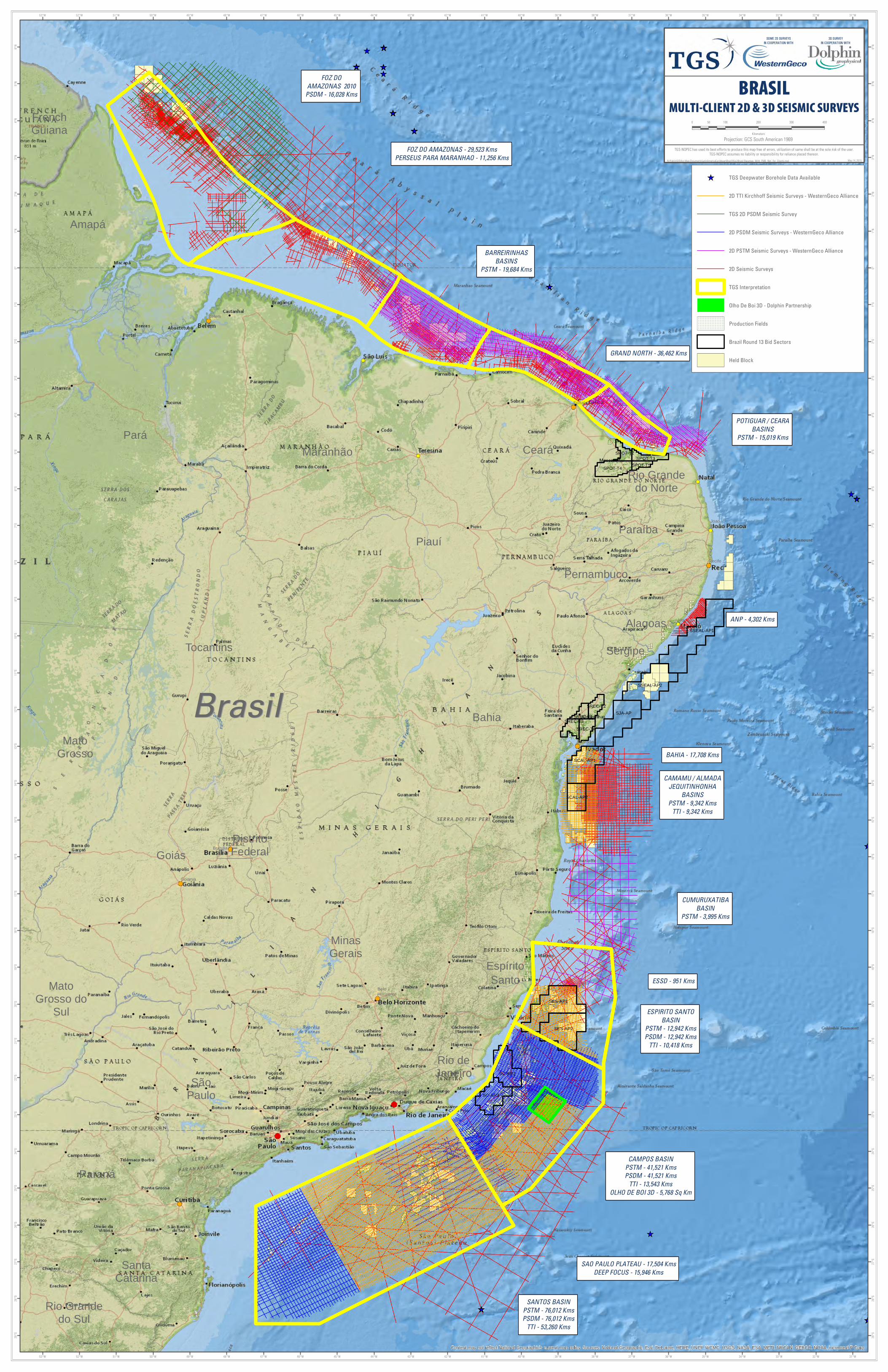
BRASILMULTI-CLIENT 2D & 3D SEISMIC SURVEYS
N:\Public\GIS\Arc Map Documents\LatinAmericaCaribbean\Brazil\KipJ\Brasil Basemap_With_FMB_Not_For_Clients.mxd May 14, 2015
Projection: GCS South American 1969
0 100 200 300 40050
Kilometers
TGS Deepwater Borehole Data Available
2D TTI Kirchhoff Seismic Surveys - WesternGeco Alliance
TGS 2D PSDM Seismic Survey
2D PSDM Seismic Surveys - WesternGeco Alliance
2D PSTM Seismic Surveys - WesternGeco Alliance
2D Seismic Surveys
TGS Interpretation
Olho De Boi 3D - Dolphin Partnership
Production Fields
Brazil Round 13 Bid Sectors
Held Block
BrasilBrasil
SOME 2D SURVEYSIN COOPERATION WITH
3D SURVEYIN COOPERATION WITH
BARREIRINHAS
BASINS
PSTM - 19,684 Kms
POTIGUAR / CEARA
BASINS
PSTM - 15,019 Kms
CAMAMU / ALMADA
JEQUITINHONHA
BASINS
PSTM - 9,342 Kms
TTI - 9,342 Kms
CUMURUXATIBA
BASIN
PSTM - 3,995 Kms
CAMPOS BASIN
PSTM - 41,521 Kms
PSDM - 41,521 Kms
TTI - 13,543 Kms
OLHO DE BOI 3D - 5,768 Sq Km
FOZ DO
AMAZONAS 2010
PSDM - 16,028 Kms
ESPIRITO SANTO
BASIN
PSTM - 12,942 Kms
PSDM - 12,942 Kms
TTI - 10,418 Kms
SANTOS BASIN
PSTM - 76,012 Kms
PSDM - 76,012 Kms
TTI - 53,260 Kms
SAO PAULO PLATEAU - 17,504 Kms
DEEP FOCUS - 15,946 Kms
BAHIA - 17,708 Kms
ANP - 4,302 Kms
GRAND NORTH - 36,462 Kms
ESSD - 951 Kms
FOZ DO AMAZONAS - 29,523 Kms
PERSEUS PARA MARANHAO - 11,256 Kms
Top Related