Characterisation of Sanguinhal Mire, Terceira Island ... · Mendes & Dias: Characterisation of...
8
Acta bot. bras. 23(3): 812-819. 2009. Characterisation of Sanguinhal Mire, Terceira Island (Azores): a protected quaking bog habitat Cândida Mendes 1,2 and Eduardo Dias 1 Received: June 27, 2008. Accepted: December 3, 2008 RESUMO – (Caracterização da Turfeira do Sanguinhal, ilha Terceira (Açores) um habitat protegido de turfeira ondulante). O Arquipélago dos Açores no Atlântico Norte é uma área importante em biodiversidade, rica em espécies e habitats raros em estado selvagem. A turfeira do Sanguinhal foi originalmente uma lagoa que evoluiu por paludificação para um habitat de turfa. Esta localiza-se na Rede Natura 2000 (União Europeia para a Proteção da Natureza e Biodiversidade, Directive do Conselho 92/43/EEC de 21 de Maio 1992 sobre a concervação de habitats naturais e da fauna e flora, Diretiva de Habitat Anexo I(b) habitat 7140) da Serra de Santa Bárbara e Pico Alto e é um bom exemplo de um tipo de turfeira de bacia, descoberto pela primeira vez em 1998. Este trabalho provê informações iniciais sobre a flora, as comunidades vegetais, a estrutura, as caracteristicas químicas da água e o regime hidrológico de superfície. Foram identificadas 41 espécies vegetais, incluindo 6 espécies do género Sphagnum, e 10 espécies de plantas vasculares endêmicas, forma identificadas oito comunidades vegetais. A profundidade máxima de turfa é de 2,5 m. A turfeira recebe água superficial de suas margens, além da precipitação interceptada e da névoa. Depois das chuvas, a água é drenada por vários pontos da turfeira onde o placic se rompeu. O pH e a condutividade das água foram medidos tendo-se verificado algumas tendências. O estado de conservação da turfeira é bom embora esteja sujeita a um crescente pastoreio por gado selvagem e a abertura de trilhos de forma desordenada altera o natural movimento de água na turfeira. Palavras-chave: condutividade, Directiva Europeia de Habitats, hidrologia, pH, vegetação ABSTRACT – (Characterisation of Sanguinhal Mire, Terceira Island (Azores): a protected quaking bog habitat). The Azores archipelago in the North Atlantic is an important area for biodiversity because it is rich in rare species and habitats, and almost undisturbed. Sanguinhal mire was originally a lake that evolved through paludification into a peat habitat. It is located inside Nature 2000 (European Union for Protection of Nature and Biodiversity, Council Directive 92/43/EEC of 21 May 1992 on the conservation of natural habitats and of wild fauna and flora, Habitat Directive Annex I(b) habitat 7140) area of Santa Bárbara and Pico Alto Mountains on the island of Terceira, and it is a good example of a basin peatland type that was first discovered in 1998. This paper provides baseline information on its flora, vegetation communities, structure, surface hydrology and chemistry. Forty-one plant species including six Sphagnum species and ten endemic vascular plants have been recorded, and eight plant communities are distinguished. The maximum peat depth is 2.5 m. The mire receives flowing water from its margins, in addition to intercepted precipitation and fog. After precipitation, water drains through several placic rupture points. Both pH and water conductivity were measured, with some ecological tendencies observed. The conservation status of the mire is good, but it is subject to increasing pressure from cattle pasture and a walking trail that constrains natural surface water movement. Key words: conductivity, European Habitats Directive, hydrology, pH, vegetation Introduction The Azores (Portugal) is the most northerly Macaronesian archipelago, comprising nine volcanic islands scattered over an area of approximately 1000 km 2 in the North Atlantic between latitudes 36º56’N-39º42’N and longitudes 25º5’W-31º12’W. The easternmost island, Santa Maria, is located approximately 1400 km from mainland Europe and the westernmost island, Flores, lies 1900 km from the North American continent. These islands host the most westerly mires in Europe. These peat formations are also the most important in the Macaronesian biogeographic region where peat formations are very scarce, due to inappropriate environmental conditions for peatland formation and development or human landscape transformation. Exploration of these rare landforms for Portugal was first proposed in 1922 (Zbszewski 1979), and some of the plant associations are included in the phytosociological system of Lüpnitz (1975). Otherwise, almost nothing was known about them until the mid-1990s. The European Union (EU) Habitats Directive was the main instrument for the establishment and maintenance of a pan-European network of spaces, known as ‘Natura 2000’. Annexes I and II of this Directive list respectively the natural habitats and species for which protection network sites of Natura 2000 are required (EU 1992). Extremely rare entities are distinguished as “priority” for conservation purposes. In the Azores there are five types of protected peatlands (Codes 7110, 7120, 7130, 7140 and 91DO), and three of these are considered priority habitats (considered near extinction by Directive Habitats). Management plans for the Azorean Natura 2000 areas were completed in 2004 and approved by the regional government in 2005. The information presented in this paper was compiled as part of the underpinning data collection exercise. Dias (1996) developed the first classification of Azorean wetland vegetation, describing six distinct communities of which four are Sphagnum-dominated; whilst Mendes (1998) distinguished five Sphagnum mire types (based in topography and plant communities), namely basin, transition, raised, valleyside and blanket. The basin mires occur in strongly endorheic valleys. Although the water supply is predominantly meteoric, arriving as precipitation and intercepted thick fog, the mire margins are rich in hummocks with characteristic vascular species whose 1 Intergraph Registered Research Laboratory, Departamento de Ciências Agrárias, Universidade dos Açores, GEVA Terra, Chã, Angra do Heroísmo, Portugal 2 Corresponding author: [email protected]
Transcript of Characterisation of Sanguinhal Mire, Terceira Island ... · Mendes & Dias: Characterisation of...
Acta bot. bras. 23(3): 812-819. 2009.
Characterisation of Sanguinhal Mire, Terceira Island (Azores): a protected quaking bog habitat
Cândida Mendes1,2 and Eduardo Dias1
Received: June 27, 2008. Accepted: December 3, 2008
RESUMO – (Caracterização da Turfeira do Sanguinhal, ilha Terceira (Açores) um habitat protegido de turfeira ondulante). O Arquipélago dosAçores no Atlântico Norte é uma área importante em biodiversidade, rica em espécies e habitats raros em estado selvagem. A turfeira doSanguinhal foi originalmente uma lagoa que evoluiu por paludificação para um habitat de turfa. Esta localiza-se na Rede Natura 2000 (UniãoEuropeia para a Proteção da Natureza e Biodiversidade, Directive do Conselho 92/43/EEC de 21 de Maio 1992 sobre a concervação de habitatsnaturais e da fauna e flora, Diretiva de Habitat Anexo I(b) habitat 7140) da Serra de Santa Bárbara e Pico Alto e é um bom exemplo de um tipode turfeira de bacia, descoberto pela primeira vez em 1998. Este trabalho provê informações iniciais sobre a flora, as comunidades vegetais,a estrutura, as caracteristicas químicas da água e o regime hidrológico de superfície. Foram identificadas 41 espécies vegetais, incluindo 6espécies do género Sphagnum, e 10 espécies de plantas vasculares endêmicas, forma identificadas oito comunidades vegetais. A profundidademáxima de turfa é de 2,5 m. A turfeira recebe água superficial de suas margens, além da precipitação interceptada e da névoa. Depois das chuvas,a água é drenada por vários pontos da turfeira onde o placic se rompeu. O pH e a condutividade das água foram medidos tendo-se verificadoalgumas tendências. O estado de conservação da turfeira é bom embora esteja sujeita a um crescente pastoreio por gado selvagem e a aberturade trilhos de forma desordenada altera o natural movimento de água na turfeira.Palavras-chave: condutividade, Directiva Europeia de Habitats, hidrologia, pH, vegetação
ABSTRACT – (Characterisation of Sanguinhal Mire, Terceira Island (Azores): a protected quaking bog habitat). The Azores archipelago inthe North Atlantic is an important area for biodiversity because it is rich in rare species and habitats, and almost undisturbed. Sanguinhal mirewas originally a lake that evolved through paludification into a peat habitat. It is located inside Nature 2000 (European Union for Protectionof Nature and Biodiversity, Council Directive 92/43/EEC of 21 May 1992 on the conservation of natural habitats and of wild fauna and flora,Habitat Directive Annex I(b) habitat 7140) area of Santa Bárbara and Pico Alto Mountains on the island of Terceira, and it is a good exampleof a basin peatland type that was first discovered in 1998. This paper provides baseline information on its flora, vegetation communities,structure, surface hydrology and chemistry. Forty-one plant species including six Sphagnum species and ten endemic vascular plants havebeen recorded, and eight plant communities are distinguished. The maximum peat depth is 2.5 m. The mire receives flowing water from itsmargins, in addition to intercepted precipitation and fog. After precipitation, water drains through several placic rupture points. Both pH andwater conductivity were measured, with some ecological tendencies observed. The conservation status of the mire is good, but it is subject toincreasing pressure from cattle pasture and a walking trail that constrains natural surface water movement.Key words: conductivity, European Habitats Directive, hydrology, pH, vegetation
Introduction
The Azores (Portugal) is the most northerlyMacaronesian archipelago, comprising nine volcanic islandsscattered over an area of approximately 1000 km2 in the NorthAtlantic between latitudes 36º56’N-39º42’N and longitudes25º5’W-31º12’W. The easternmost island, Santa Maria, islocated approximately 1400 km from mainland Europe andthe westernmost island, Flores, lies 1900 km from the NorthAmerican continent. These islands host the most westerlymires in Europe. These peat formations are also the mostimportant in the Macaronesian biogeographic region wherepeat formations are very scarce, due to inappropriateenvironmental conditions for peatland formation anddevelopment or human landscape transformation.Exploration of these rare landforms for Portugal was firstproposed in 1922 (Zbszewski 1979), and some of the plantassociations are included in the phytosociological systemof Lüpnitz (1975). Otherwise, almost nothing was knownabout them until the mid-1990s.
The European Union (EU) Habitats Directive was themain instrument for the establishment and maintenance of apan-European network of spaces, known as ‘Natura 2000’.
Annexes I and II of this Directive list respectively the naturalhabitats and species for which protection network sites ofNatura 2000 are required (EU 1992). Extremely rare entitiesare distinguished as “priority” for conservation purposes.In the Azores there are five types of protected peatlands(Codes 7110, 7120, 7130, 7140 and 91DO), and three of theseare considered priority habitats (considered near extinctionby Directive Habitats).
Management plans for the Azorean Natura 2000 areaswere completed in 2004 and approved by the regionalgovernment in 2005. The information presented in this paperwas compiled as part of the underpinning data collectionexercise.
Dias (1996) developed the first classification of Azoreanwetland vegetation, describing six distinct communities ofwhich four are Sphagnum-dominated; whilst Mendes (1998)distinguished five Sphagnum mire types (based intopography and plant communities), namely basin,transition, raised, valleyside and blanket. The basin miresoccur in strongly endorheic valleys. Although the watersupply is predominantly meteoric, arriving as precipitationand intercepted thick fog, the mire margins are rich inhummocks with characteristic vascular species whose
1 Intergraph Registered Research Laboratory, Departamento de Ciências Agrárias, Universidade dos Açores, GEVA Terra, Chã, Angra doHeroísmo, Portugal
2 Corresponding author: [email protected]
v23n3_22.pmd 23/9/2009, 11:34812
813Mendes & Dias: Characterisation of Sanguinhal Mire, Terceira Island (Azores): a protected quaking bog habitat
development can be attributed to the ingress of water withentrained oxygen and nutrients from the surrounding mineralcatchments. The hummocky peripheral zone is less extensivein steep catchments than in locations where the surroundinghillsides slope gently and thus drain sluggishly. Water isstagnant and the water table is usually at ground level inthe swards at the centre of the basins. This basin mire reflectsthe actual process of succession, as peat accumulates inopen water to produce rainwater-fed bog isolated fromgroundwater influence. Many of these systems are veryunstable underfoot and can therefore also be described as‘quaking bogs’. Transition mires and quaking bogs havewide European distribution (European EnvironmentalAgency 2008) but appear to be relatively scarce in theMediterranean region (Joint Nature Conservation Committee2008). These formations have never been described for theMacaronesian Region and are extremely rare in the Azoresislands (until now found on Terceira and Flores islands).This paper presents a first description of this protectedmire type and a first reference on water chemistry of Azoreanmires, as a foundation for further research and publications.
The study area is on Terceira Island, located near thecentre of the Azores archipelago and extends toapproximately 402 km2. Its highest mountain, the SantaBárbara volcano (1023 m), hosts the largest concentration ofbiodiversity within the natural areas of the Azores, and mostof its biotopes are in excellent conservation condition. Thusthe Natura 2000 Site of Community Importance (SCI) classified“Santa Bárbara Mountain and Pico Alto” as one of thebiodiversity hotspots of the Macaronesian biogeographicregion, with 18 protected habitats and 10 protected species,of which five habitats and two species have priority status.
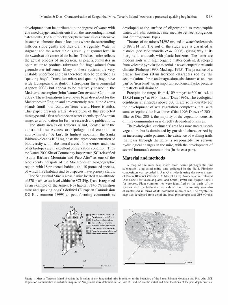
The Sanguinhal Mire is a basin mire located at an altitudeof 570 m above sea level within the SCI (Fig. 1) and is regardedas an example of the Annex I(b) habitat 7140 (‘transitionmire and quaking bogs”) defined (European CommissionDG Environment 1999) as peat forming communities
developed at the surface of oligotrophic to mesotrophicwater, with characteristics intermediate between soligenousand ombrogenous types.
The area of the mire is 74,985 m2, and its watershed extendsto 897,314 m2. The soil of the study area is classified ashistosol (see Montanarella et al. 2006), giving way at itsmargins to andosols with placic horizons. The latter aremodern soils with high organic matter content, developedfrom volcanic pyroclastic material in a wet temperate Atlanticclimate (Pinheiro 1990; Madruga 1995). The presence of aplacic horizon (Bsm horizon characterised by theaccumulation of iron and magnesium, also known as an ‘ironpan’ or ‘iron band’) is an important ecological factor becauseit restricts soil drainage.
Precipitation ranges from 4,109 mm yr-1 at 600 m a.s.l. to13,054 mm yr-1 at 980 m a.s.l. (Dias 1996). The ecologicalconditions at altitudes above 500 m are so favourable forthe development of wet vegetation complexes that, withsome exceptions like lava domes (Dias 1996; Dias et al. 2004;Elias & Dias 2004), the majority of the vegetation consistsof mire communities or is directly dependent on mires.
The hydrological catchments’ area has some natural shrubvegetation, but is dominated by grassland characterized byan increasing cattle pasture. The existence of walking trailsthat pass through the mire is responsible for serioushydrological changes in the mire, with the development ofseveral hummock communities (in the east part).
Material and methodsA map of the mire was made from aerial photographs and
subsequently adjusted using data collected in the field. Floristiccomposition was recorded in 5 m×5 m relevés using the cover classesof Braun Blanquet (Westhoff & Maarel 1978). Nomenclature followedDias (2004) for vascular plants, and Smith (1980) and Sjögren (2001)for mosses. Plant communities were identified on the basis of thespecies with the highest cover values. Each community was alsocharacterised in terms of its dominant micro-relief. The vegetationmap was developed from aerial and local photographs and GPS (Global
Figure 1. Map of Terceira Island showing the location of the Sanguinhal mire in relation to the boundary of the Santa Bárbara Mountain and Pico Alto SCI.Vegetation communities distribution map in the Sanguinhal mire delimitation. A1, A2, B1 and B2 are the initial and final locations of the peat depth profiles.
v23n3_22.pmd 23/9/2009, 11:34813
Mendes & Dias: Characterisation of Sanguinhal Mire, Terceira Island (Azores): a protected quaking bog habitat814
Position System) points in a Geomedia environment by GEVA, anIntergraph Registered Research Laboratory.
Water chemistry and depth of the mire are important fordetermining ecological niches of plant species present in mires(Bragazza 1999). pH and conductivity were measured in the fieldusing WTW pH 320 - pH Meter and WTW LF - Conductivity Meter.The depth of peat was measured. For this purpose, two profiles werelaid out with PVC tubes, along the major and minor axes of the mirerespectively (Fig. 1).
Ecological attributes of wetlands such as floristic diversity,vegetation and peat characteristics depend upon the maintenance oftheir hydrology. Therefore a preliminary analysis of surface watermovement was carried out using the Watershed Delineator extensionto the ArcView GIS package (see e.g. Romanek 1998).
Results
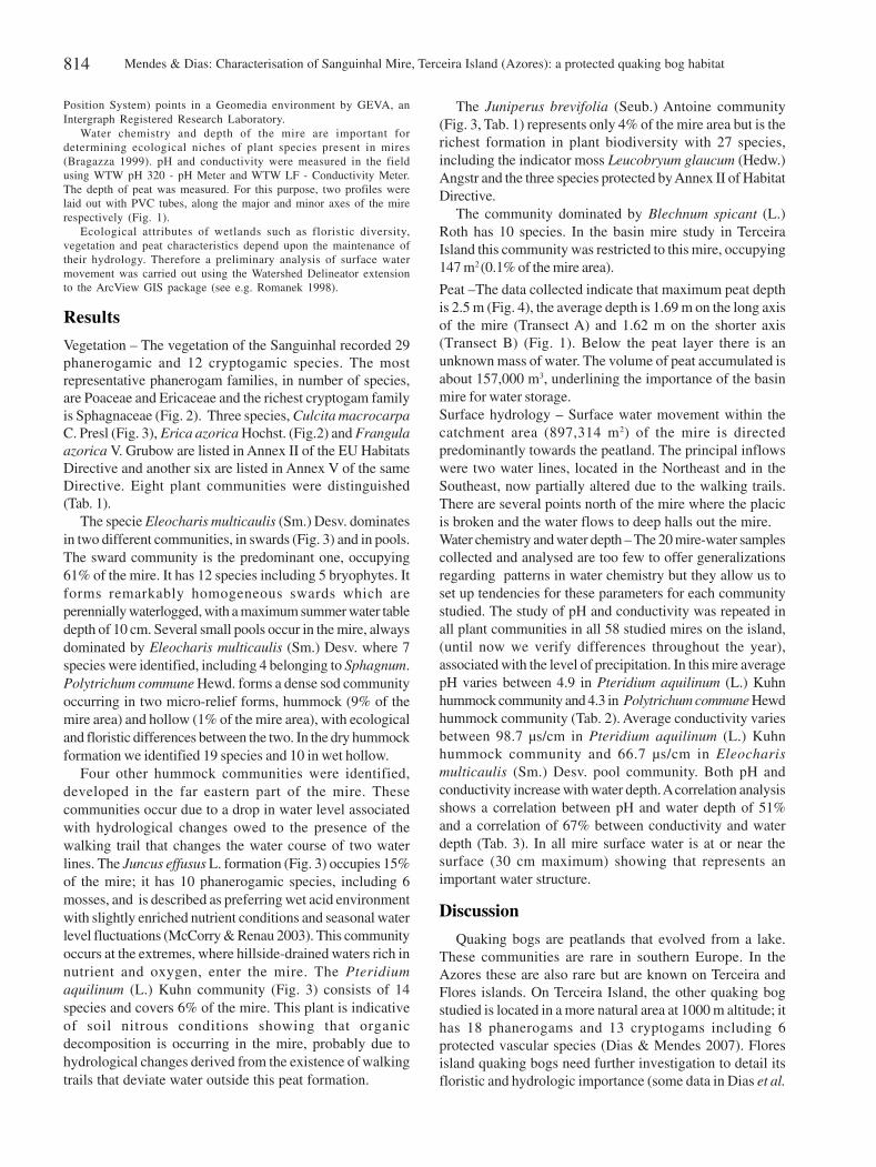
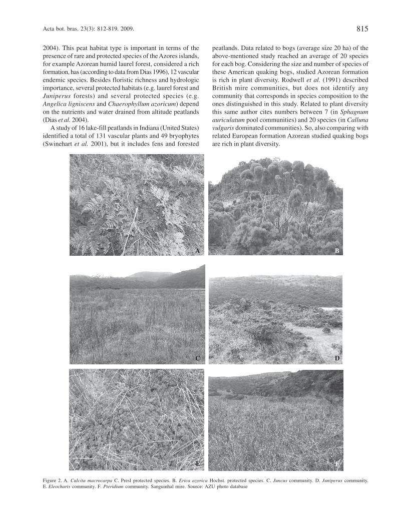
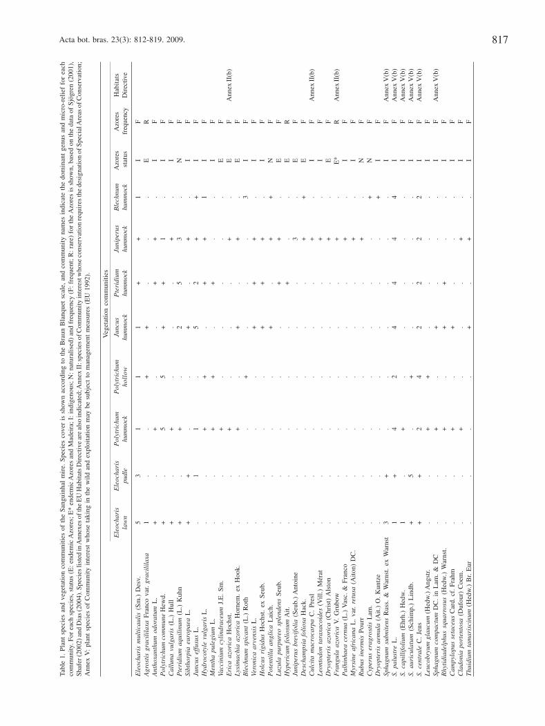
Vegetation – The vegetation of the Sanguinhal recorded 29phanerogamic and 12 cryptogamic species. The mostrepresentative phanerogam families, in number of species,are Poaceae and Ericaceae and the richest cryptogam familyis Sphagnaceae (Fig. 2). Three species, Culcita macrocarpaC. Presl (Fig. 3), Erica azorica Hochst. (Fig.2) and Frangulaazorica V. Grubow are listed in Annex II of the EU HabitatsDirective and another six are listed in Annex V of the sameDirective. Eight plant communities were distinguished(Tab. 1).
The specie Eleocharis multicaulis (Sm.) Desv. dominatesin two different communities, in swards (Fig. 3) and in pools.The sward community is the predominant one, occupying61% of the mire. It has 12 species including 5 bryophytes. Itforms remarkably homogeneous swards which areperennially waterlogged, with a maximum summer water tabledepth of 10 cm. Several small pools occur in the mire, alwaysdominated by Eleocharis multicaulis (Sm.) Desv. where 7species were identified, including 4 belonging to Sphagnum.Polytrichum commune Hewd. forms a dense sod communityoccurring in two micro-relief forms, hummock (9% of themire area) and hollow (1% of the mire area), with ecologicaland floristic differences between the two. In the dry hummockformation we identified 19 species and 10 in wet hollow.
Four other hummock communities were identified,developed in the far eastern part of the mire. Thesecommunities occur due to a drop in water level associatedwith hydrological changes owed to the presence of thewalking trail that changes the water course of two waterlines. The Juncus effusus L. formation (Fig. 3) occupies 15%of the mire; it has 10 phanerogamic species, including 6mosses, and is described as preferring wet acid environmentwith slightly enriched nutrient conditions and seasonal waterlevel fluctuations (McCorry & Renau 2003). This communityoccurs at the extremes, where hillside-drained waters rich innutrient and oxygen, enter the mire. The Pteridiumaquilinum (L.) Kuhn community (Fig. 3) consists of 14species and covers 6% of the mire. This plant is indicativeof soil nitrous conditions showing that organicdecomposition is occurring in the mire, probably due tohydrological changes derived from the existence of walkingtrails that deviate water outside this peat formation.
The Juniperus brevifolia (Seub.) Antoine community(Fig. 3, Tab. 1) represents only 4% of the mire area but is therichest formation in plant biodiversity with 27 species,including the indicator moss Leucobryum glaucum (Hedw.)Angstr and the three species protected by Annex II of HabitatDirective.
The community dominated by Blechnum spicant (L.)Roth has 10 species. In the basin mire study in TerceiraIsland this community was restricted to this mire, occupying147 m2 (0.1% of the mire area).
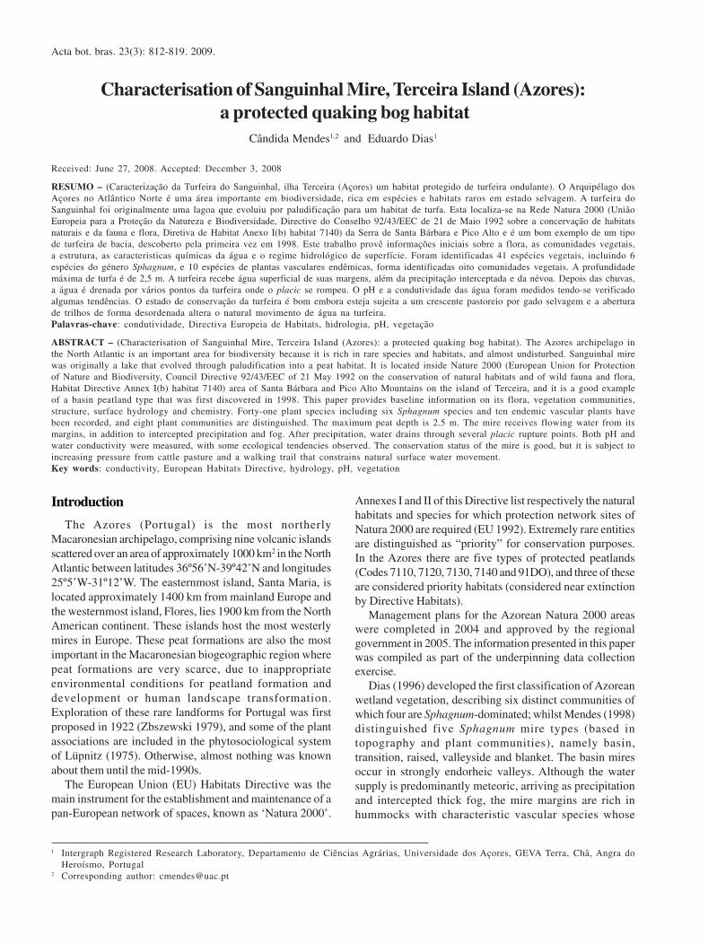
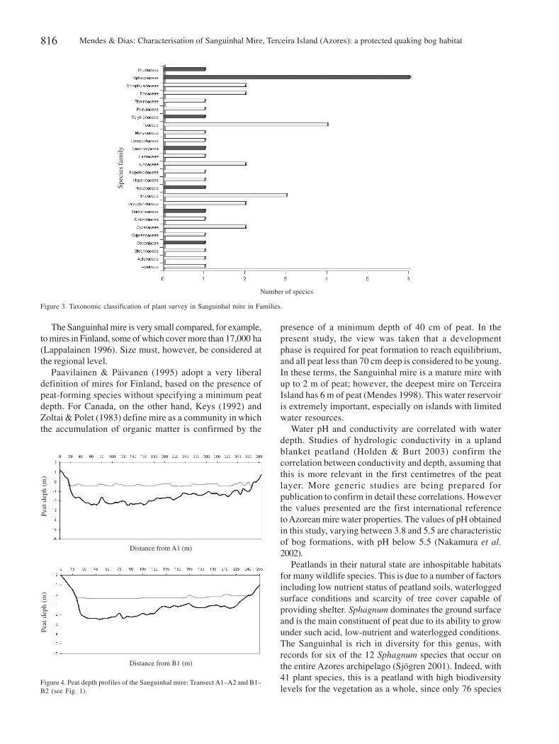
Peat –The data collected indicate that maximum peat depthis 2.5 m (Fig. 4), the average depth is 1.69 m on the long axisof the mire (Transect A) and 1.62 m on the shorter axis(Transect B) (Fig. 1). Below the peat layer there is anunknown mass of water. The volume of peat accumulated isabout 157,000 m3, underlining the importance of the basinmire for water storage.Surface hydrology – Surface water movement within thecatchment area (897,314 m2) of the mire is directedpredominantly towards the peatland. The principal inflowswere two water lines, located in the Northeast and in theSoutheast, now partially altered due to the walking trails.There are several points north of the mire where the placicis broken and the water flows to deep halls out the mire.Water chemistry and water depth – The 20 mire-water samplescollected and analysed are too few to offer generalizationsregarding patterns in water chemistry but they allow us toset up tendencies for these parameters for each communitystudied. The study of pH and conductivity was repeated inall plant communities in all 58 studied mires on the island,(until now we verify differences throughout the year),associated with the level of precipitation. In this mire averagepH varies between 4.9 in Pteridium aquilinum (L.) Kuhnhummock community and 4.3 in Polytrichum commune Hewdhummock community (Tab. 2). Average conductivity variesbetween 98.7 µs/cm in Pteridium aquilinum (L.) Kuhnhummock community and 66.7 µs/cm in Eleocharismulticaulis (Sm.) Desv. pool community. Both pH andconductivity increase with water depth. A correlation analysisshows a correlation between pH and water depth of 51%and a correlation of 67% between conductivity and waterdepth (Tab. 3). In all mire surface water is at or near thesurface (30 cm maximum) showing that represents animportant water structure.
Discussion
Quaking bogs are peatlands that evolved from a lake.These communities are rare in southern Europe. In theAzores these are also rare but are known on Terceira andFlores islands. On Terceira Island, the other quaking bogstudied is located in a more natural area at 1000 m altitude; ithas 18 phanerogams and 13 cryptogams including 6protected vascular species (Dias & Mendes 2007). Floresisland quaking bogs need further investigation to detail itsfloristic and hydrologic importance (some data in Dias et al.
v23n3_22.pmd 23/9/2009, 11:34814
Acta bot. bras. 23(3): 812-819. 2009. 815
Figure 2. A. Culcita macrocarpa C. Presl protected species. B. Erica azorica Hochst. protected species. C. Juncus community. D. Juniperus community.E. Eleocharis community. F. Pteridium community. Sanguinhal mire. Source: AZU photo database
2004). This peat habitat type is important in terms of thepresence of rare and protected species of the Azores islands,for example Azorean humid laurel forest, considered a richformation, has (according to data from Dias 1996), 12 vascularendemic species. Besides floristic richness and hydrologicimportance, several protected habitats (e.g. laurel forest andJuniperus forests) and several protected species (e.g.Angelica ligniscens and Chaerophyllum azoricum) dependon the nutrients and water drained from altitude peatlands(Dias et al. 2004).
A study of 16 lake-fill peatlands in Indiana (United States)identified a total of 131 vascular plants and 49 bryophytes(Swinehart et al. 2001), but it includes fens and forested
peatlands. Data related to bogs (average size 20 ha) of theabove-mentioned study reached an average of 20 speciesfor each bog. Considering the size and number of species ofthese American quaking bogs, studied Azorean formationis rich in plant diversity. Rodwell et al. (1991) describedBritish mire communities, but does not identify anycommunity that corresponds in species composition to theones distinguished in this study. Related to plant diversitythis same author cites numbers between 7 (in Sphagnumauriculatum pool communities) and 20 species (in Callunavulgaris dominated communities). So, also comparing withrelated European formation Azorean studied quaking bogsare rich in plant diversity.
A B
C D
E F
v23n3_22.pmd 23/9/2009, 11:34815
Mendes & Dias: Characterisation of Sanguinhal Mire, Terceira Island (Azores): a protected quaking bog habitat816
The Sanguinhal mire is very small compared, for example,to mires in Finland, some of which cover more than 17,000 ha(Lappalainen 1996). Size must, however, be considered atthe regional level.
Paavilainen & Päivanen (1995) adopt a very liberaldefinition of mires for Finland, based on the presence ofpeat-forming species without specifying a minimum peatdepth. For Canada, on the other hand, Keys (1992) andZoltai & Polet (1983) define mire as a community in whichthe accumulation of organic matter is confirmed by the
presence of a minimum depth of 40 cm of peat. In thepresent study, the view was taken that a developmentphase is required for peat formation to reach equilibrium,and all peat less than 70 cm deep is considered to be young.In these terms, the Sanguinhal mire is a mature mire withup to 2 m of peat; however, the deepest mire on TerceiraIsland has 6 m of peat (Mendes 1998). This water reservoiris extremely important, especially on islands with limitedwater resources.
Water pH and conductivity are correlated with waterdepth. Studies of hydrologic conductivity in a uplandblanket peatland (Holden & Burt 2003) confirm thecorrelation between conductivity and depth, assuming thatthis is more relevant in the first centimetres of the peatlayer. More generic studies are being prepared forpublication to confirm in detail these correlations. Howeverthe values presented are the first international referenceto Azorean mire water properties. The values of pH obtainedin this study, varying between 3.8 and 5.5 are characteristicof bog formations, with pH below 5.5 (Nakamura et al.2002).
Peatlands in their natural state are inhospitable habitatsfor many wildlife species. This is due to a number of factorsincluding low nutrient status of peatland soils, waterloggedsurface conditions and scarcity of tree cover capable ofproviding shelter. Sphagnum dominates the ground surfaceand is the main constituent of peat due to its ability to growunder such acid, low-nutrient and waterlogged conditions.The Sanguinhal is rich in diversity for this genus, withrecords for six of the 12 Sphagnum species that occur onthe entire Azores archipelago (Sjögren 2001). Indeed, with41 plant species, this is a peatland with high biodiversitylevels for the vegetation as a whole, since only 76 species
Number of species
Spe
cies
fam
ily
Figure 3. Taxonomic classification of plant survey in Sanguinhal mire in Families.
Figure 4. Peat depth profiles of the Sanguinhal mire: Transect A1–A2 and B1–B2 (see Fig. 1).
Pea
t dep
h (m
)P
eat d
eph
(m)
Distance from A1 (m)
Distance from B1 (m)
v23n3_22.pmd 23/9/2009, 11:34816
Acta bot. bras. 23(3): 812-819. 2009. 817
Tabl
e 1.
Pla
nt s
peci
es a
nd v
eget
atio
n co
mm
unit
ies
of t
he S
angu
inha
l m
ire.
Spe
cies
cov
er i
s sh
own
acco
rdin
g to
the
Bra
un B
lanq
uet
scal
e, a
nd c
omm
unit
y na
mes
ind
icat
e th
e do
min
ant
genu
s an
d m
icro
-rel
ief
for
each
com
mun
ity.
For
eac
h sp
ecie
s, s
tatu
s (E
: end
emic
Azo
res;
E*
ende
mic
Azo
res
and
Mad
eira
; I: i
ndig
enou
s; N
: nat
ural
ised
) an
d fr
eque
ncy
(F: f
requ
ent;
R: r
are)
for
the
Azo
res
is s
how
n, b
ased
on
the
data
of
Sjö
gren
(20
01),
Sha
fer (
2002
) and
Dia
s (2
004)
. Spe
cies
list
ed in
Ann
exes
of t
he E
U H
abit
ats
Dir
ecti
ve a
re a
lso
indi
cate
d; A
nnex
II: s
peci
es o
f Com
mun
ity
inte
rest
who
se c
onse
rvat
ion
requ
ires
the
desi
gnat
ion
of S
peci
al A
reas
of C
onse
rvat
ion;
Ann
ex V
: pl
ant
spec
ies
of C
omm
unit
y in
tere
st w
hose
tak
ing
in t
he w
ild
and
expl
oita
tion
may
be
subj
ect
to m
anag
emen
t m
easu
res
(EU
199
2).
Veg
etat
ion
com
mun
itie
s
Ele
ocha
ris
Ele
ocha
ris
Pol
ytri
chum
Pol
ytri
chum
Junc
usP
teri
dium
Juni
peru
sB
lech
num
Azo
res
Azo
res
Hab
itat
sla
wn
pudl
ehu
mm
ock
holl
owhu
mm
ock
hum
moc
khu
mm
ock
hum
moc
k s
tatu
s fr
eque
ncy
Dir
ectiv
e
Ele
ocha
ris
mul
tica
ulis
(S
m.)
Des
v.5
31
11
++
1I
F
Agr
osti
s gr
acil
ilax
a F
ranc
o va
r. gr
acil
ilax
a1
..
++
..
.E
RA
ntho
xant
hum
odo
ratu
m L
.+
.+
..
++
.I
FP
olyt
rich
um c
omm
une
Hew
d.+
.5
5+
+1
.I
FC
allu
na v
ulga
ris
(L.)
Hul
l+
.+
..
.+
.I
FP
teri
dium
aqu
ilin
um (
L.)
Kuh
n+
.+
.2
53
.N
FSi
btho
rpia
eur
opae
a L
.+
+.
.+
.+
.I
FJu
ncus
eff
usus
L.
.1
1.
52
++
IF
Hyd
roco
tyle
vul
gari
s L
..
.+
+.
++
1I
FM
enth
a pu
legi
um L
..
.+
+.
+.
.I
FVa
ccin
ium
cyl
indr
aceu
m J
.E.
Sm
..
.+
..
..
.E
FE
rica
azo
rica
Hoc
hst.
..
+.
..
+.
EF
Ann
ex II
(b)
Lys
imac
hia
azor
ica
Hor
nem
. ex
Hoo
k..
.+
.+
.+
.E
FB
lech
num
spi
cant
(L
.) R
oth
..
.+
..
.3
IF
Vero
nica
arv
ensi
s L
..
..
.+
++
.I
FH
olcu
s ri
gidu
s H
ochs
t. ex
Seu
b..
..
.+
++
.I
FP
oten
till
a an
glic
a L
aich
..
..
.+
.+
+N
FL
uzul
a pu
rpur
eo s
plen
dens
Seu
b..
..
..
++
.E
FH
yper
icum
fol
iosu
m A
it.
..
..
.+
..
ER
Juni
peru
s br
evif
olia
(S
eub.
) A
ntoi
ne.
..
..
.3
.E
FD
esch
amps
ia f
olio
sa H
ack.
..
..
..
++
EF
Cul
cita
mac
roca
rpa
C.
Pre
sl.
..
..
.+
.I
FA
nnex
II(b
)L
eont
odon
tar
axac
oide
s (V
ill.)
Mér
at.
..
..
.+
.I
FD
ryop
teri
s az
oric
a (C
hris
t) A
lsto
n.
..
..
.+
.E
FF
rang
ula
azor
ica
V.
Gru
bow
..
..
..
+.
E*
RA
nnex
II(b
)P
alhi
nhae
a ce
rnua
(L
.) V
asc.
& F
ranc
o.
..
..
.+
.I
FM
yrsi
ne a
fric
ana
L.
var.
retu
sa (
Ait
on)
DC
..
..
..
.+
.I
FR
ubus
ine
rmis
Pou
rr.
..
..
.+
.N
FC
yper
us e
ragr
osti
s L
am.
..
..
..
.+
NF
Dry
opte
ris
aem
ula
(Ait
.) O
. K
untz
e.
..
..
..
+I
FSp
hagn
um s
ubni
tens
Rus
s. &
War
nst.
ex W
arns
t3
+.
..
..
.I
FA
nnex
V(b
)S.
pal
ustr
e L
.1
+4
24
44
4I
FA
nnex
V(b
)S.
cap
illi
foli
um (
Ehr
h.)
Hed
w.
1.
+.
..
..
IF
Ann
ex V
(b)
S. a
uric
ulat
um (
Sch
imp.
) L
indb
.+
5.
+.
..
.I
FA
nnex
V(b
)S.
cen
tral
e C
. Je
ns+
+2
42
22
2I
FA
nnex
V(b
)L
euco
bryu
m g
lauc
um (
Hed
w.)
Ang
str.
..
++
..
..
IF
Spha
gnum
com
pact
um D
C.
in L
am.
& D
C.
.+
.+
..
.I
FA
nnex
V(b
)R
hyti
diad
elph
us s
quar
rosu
s (H
edw
.) W
arns
t..
.+
.+
+.
.I
FC
ampy
lopu
s se
tace
us C
ard.
cf.
Fra
hm.
.+
.+
..
.I
FC
lado
nia
port
ento
sa (
Duf
our)
Coe
m.
..
+.
..
+.
IF
Thu
idiu
m t
amar
isci
num
(H
edw
.) B
r. E
ur.
..
.+
.+
.I
F
v23n3_22.pmd 23/9/2009, 11:34817
Mendes & Dias: Characterisation of Sanguinhal Mire, Terceira Island (Azores): a protected quaking bog habitat818
were identified during a survey of 58 basin mires on TerceiraIsland, with an average of 24 species per site (Mendes 1998).
The good conservation status of this peatland isdemonstrated by the fact that the 41 plant species recordedinclude ten endemics (three of which are regarded as rare),three protected species and contains no exotic species forthe island (Tab.1). The Sanguinhal Mire is a typical exampleof the basin mires on Terceira Island in that it has a marginalcommunity which is dominated by Juncus effusus L. Sevenadditional plant communities have been identified, twodominated by Eleocharis multicaulis (Sm.) Desv (pools andswards), two dominated by Polytrichum commune Hewd.(hummock and hollows), one by Pteridium aquilinum (L.)Kuhn, Blechnum spicant (L.) and Juniperus brevifolia(Seub.) Antoine (all in hummocks).
It is important that the pasture on this mire watershedbe controlled. Measures should be taken to minimize theimpact of the walking trail, in order to maintain (evenimprove) water quantity and quality for the Sanguinhalmire itself but also for the other dependent habitatsdownstream.
Given the importance of peatlands, even if viewed nomore widely than at regional scale, this is the first work thatallows a detailed description of an Azorean Sphagnumquaking mire. It provides a starting-point for building anunderstanding of these complex habitats, but also revealsan urgent need for the acquisition of further knowledge tosupport measures for their conservation. However, the factthat most of the Terceira Island mires lie within Natura 2000areas is likely to favour their conservation and study.
ReferencesBragazza, L. 1999. Spatial patterns of plant species in a poor
mire on the Southern Alps (Italy). Plant Biosystems 133:83-92.
Dias, E. (1996) Vegetação Natural dos Açores. Ecologia eSintaxonomia das Florestas Naturais (Natural Vegetationof the Azores. Ecology and Syntaxonomy of Natural Forests).PhD Dissertation, Department of Agricultural Sciences, AzoresUniversity, Angra do Heroísmo (in Portuguese).
Dias, E. 2004. Lista de Referência da Flora dos Açores (ReferenceList of the Flora of the Azores). Applied Vegetation EcologyInvestigation Group, Azores University, Angra do Heroísmo.http://www.angra.uac.pt/geva/WEBGEVA/Scheklistacores/ScheklistAcoresstart.htm (in Portuguese).
Dias, E; Elias, R. & Nunes, V. 2004. Vegetation mapping and natureconservation: a case study in Terceira Island (Azores).Biodiversity and Conservation 13: 1519-1539.
Dias, E., Mendes, C.; Melo, C.; Pereira, D.; Elias R.; Elias S. &Pereira, F. 2004. Plano de Gestão Sectoriais das áreasTerrestres da Rede Natura 2000 dos Açores (SectorialManagement Plans of Azores Natura 2000 Terrestrial ProtectedAreas). Departamento de Ciências Agrárias. Universidade dosAçores & Direcção Regional dos Serviços de Ambiente.
Dias, E. & Mendes C. 2007. Characterization on a Basin Mire in theAzores Archipelago. Mires and Peat. v. 2 Article 8, http://www.mires-and-peat.net
Elias, R. & Dias, E. 2004. Primary succession on lava domes on Terceira(Azores). Journal of Conservation Science 15: 331-338.
EU 1992. Council Directive 92/43/EEC of 21 May 1992 on theconservation of natural habitats and of wild fauna andflora. Available online at: http://ec.europa.eu/environment/n a t u r e / n a t u r e _ c o n s e r v a t i o n / e u _ n a t u r e _ l e g i s l a t i o n /habitats_directive/index_en.htm
European Environmental Agency 2008. Transition mires andquaking bogs. Available online at: http://eunis.eea.europa.eu/habitats-factsheet.jsp?tab=1&idHabitat=10145
Holden, J. & Burt, T.P. 2003. Hydraulic conductivity in uplandblanket peat: measurement and variability. HydrologicalProcesses 17: 1227-1237.
Joint Nature Conservation Committee 2008. 7140 Transitionmires and quaking bogs. Available online at: http://w w w. j n c c . g o v . u k / P r o t e c t e d S i t e s / S A C S e l e c t i o n /habitat.asp?FeatureIntCode=H7140
Keys, D. 1992. Canadian peat harvesting and the environment.Sustaining Wetlands 3: 1-14.
Lappalainen, E. 1996. Peatlands and peat resources in Finland.Pp. 36-38. In: H. Vasander (ed.). Peatlands in Finland, FinnishPeatland Society, Helsinki.
Lüpniz, D. 1975. Geobotanische Studien zur Natürlichen Vegetationder Azorean unter Berücksichtigung der Chorologie innerhalbMakaronensis (Geobotanical studies of the natural vegetationof the Azores) Beitr. Biol. Pflazen 51: 149-317 (in German).
Madruga, J. 1995. Caracterização e génese do horizonte plácicoem solos vulcânicos do arquipélago dos Açores(Chacterization and genesis of the placic horizon in the volcanicsoils of the Azores Archipelago). PhD dissertation, AzoresUniversity, Angra do Heroísmo (in Portuguese).
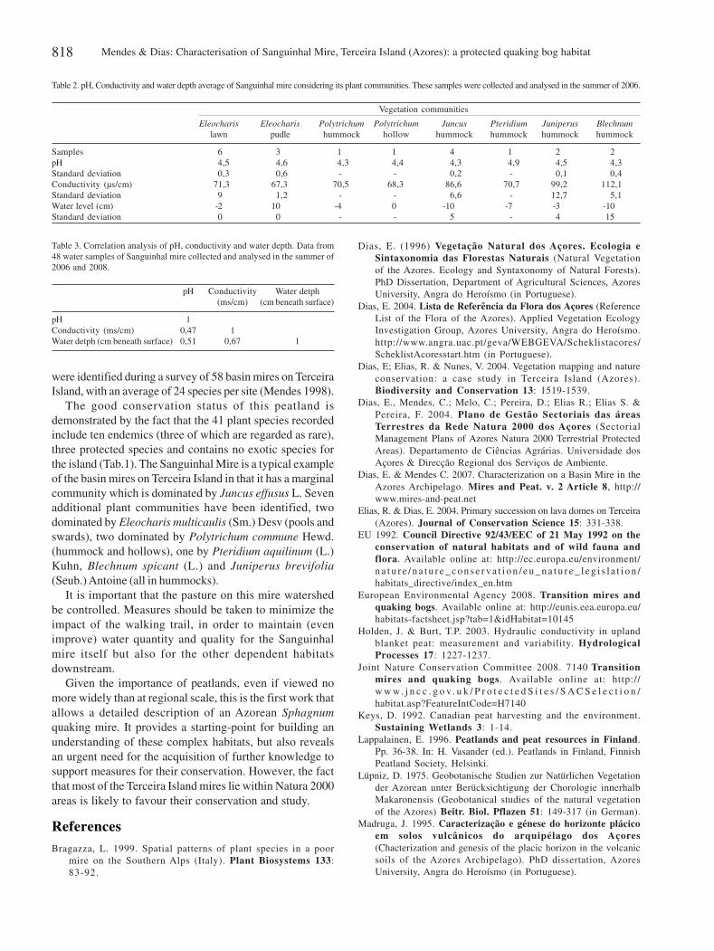
Table 2. pH, Conductivity and water depth average of Sanguinhal mire considering its plant communities. These samples were collected and analysed in the summer of 2006.
Vegetation communities
Eleocharis Eleocharis Polytrichum Polytrichum Juncus Pteridium Juniperus Blechnumlawn pudle hummock hollow hummock hummock hummock hummock
Samples 6 3 1 1 4 1 2 2pH 4,5 4,6 4,3 4,4 4,3 4,9 4,5 4,3Standard deviation 0,3 0,6 - - 0,2 - 0,1 0,4Conductivity (µs/cm) 71,3 67,3 70,5 68,3 86,6 70,7 99,2 112,1Standard deviation 9 1,2 - - 6,6 - 12,7 5,1Water level (cm) -2 10 -4 0 -10 -7 -3 -10Standard deviation 0 0 - - 5 - 4 15
Table 3. Correlation analysis of pH, conductivity and water depth. Data from48 water samples of Sanguinhal mire collected and analysed in the summer of2006 and 2008.
pH Conductivity Water detph(ms/cm) (cm beneath surface)
pH 1Conductivity (ms/cm) 0,47 1Water detph (cm beneath surface) 0,51 0,67 1
v23n3_22.pmd 23/9/2009, 11:34818
Acta bot. bras. 23(3): 812-819. 2009. 819
McCorry, M. & Renou F. 2003. Ecology and managent of Juncuseffusus (soft rush) on cutaway Peatlands. Forest EcossystemResearch Group. Report Number 69. Department ofEnvironmental Resource Management. University CollegeDublin. Dublin 4.
Mendes, C. & Dias, E. 2002. Ecologia e Vegetação das Turfeirasde Sphagnum da Ilha Terceira - Açores (Ecology andVegetation of the Sphagnum mires of Terceira Island - Azores).Herbário da Universidade dos Açores, Angra do Heroísmo (inPortuguese).
Mendes C. 1998. Contributo para a Caracterização dasTurfeiras de Sphagnum da ilha Terceira (Contribution tothe characterisation of Sphagnum mires of Terceira Island).Relatório de Estágio, Universidade dos Açores, Angra doHeroísmo (in Portuguese).
Montanarella, L.; Jones, R.J.A. & Hiederer, R. 2006. The distributionof peatland in Europe. Mires and Peat, 1: 1-10. http://www.mires-and-peat.net/map01/map_1_1.htm.
Paavilainen, E. & Päivanen, J. 1995. Peatland Forestry: Ecologyand Principles. Ecological Studies 111, Springer-Verlag, Berlin.
Pinheiro, J. 1990. Estudo dos principais tipos de solos da ilhaTerceira-Açores (Study of the major soil types of Terceira Island,Azores). PhD dissertation, Azores University Department ofAgricultural Sciences, Angra do Heroísmo (in Portuguese).
Rodwell, J.S. (ed.); Pigott, C.D.; Ratcliffe D.A.; Malloch, A.J.C.;Birks, H.J.B.; Proctor, M.C.F.; Shimwell, D.W.; Huntley J.P.;Radford E.; Wigginton, M.J. & Wilkins P. 1991. BritishPlant Community: Mires and Heaths. v.2. Cambrigde,UK Joint Nature Conservation Comittee. CambridgeUniversity Press.
Versão eletrônica do artigo em www.scielo.br/abb e http://www.botanica.org.br/acta/ojs
Romanek, A. 1998. GIS Enviro98 - EnvironmentalRepresentation. Center for Research in Water Resources. TheUniversity of Texas at Austin. http://www.crwr.utexas.edu/gis/gisenv98/envrep/envrep.html
Shäfer, H. 2002. Flora of the Azores. Margraf Verlag, Weikersheim,DE.
Sjögren, E. 2001. Distribution of Azorean Bryophytes up to 1999,their island distribution and information on their presenceelsewhere, including Madeira and Canary Island. Boletim doMuseu Municipal do Funchal, Sup. 7: 1-89.
Smith, A. 1980. The Moss Flora of Britain and Ireland.Cambridge University Press.
Swinehart, A.L.; Parker, G.R. & Wujek, D.E. 2001. The structureand composition of vegetation in the lake-fill peatlands ofIndiana. Proceedings of the Indiana Academy of Sciences110: 51-78.
Nakamura T.; Uemura S. & Yabe, K. 2002. Hydrochemical Regimeof Fen and Bog in North Japanese Mires as an Influence onHabitat and Above-Ground Biomass of Carex Species. TheJournal of Ecology 90: 1017-1023.
Zbyszewsli, G. 1979. Ocorrências de Turfas em Portugal (Theoccurrence of peat in Portugal). Boletim de Minas, DirecçãoGeral de Geologia e Minas 6: 137-216.
Zoltai, S.C. & Pollet, F.C. 1983. Wetlands in Canada: theirclassification, distribution and use. Pp. 245-268. In: A.J.P.Gore (ed.). Mires: Swamp, Bog, Fen and Moor. Regional Studies.Ecosystems of the World, 4B, Elsevier, Amsterdam.
Westhoff, V. & Maarel, E. 1978. The Braun-Blanquet approach.Pp. 289-398. In: R.H. Whittaker (ed.). Classification of PlantCommunities, Junk, The Hague.
v23n3_22.pmd 23/9/2009, 11:34819